Route Editor

| Guide | ♦ | 6 Triplogs | 0 Topics |
details | drive | no permit | forecast | 🔥 route |
stats |
photos | triplogs | topics | location |
| 36 | 6 | 0 |
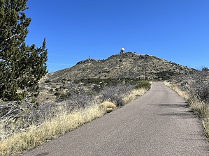
The Big Golfball by MEWhiteman  Overview OverviewIf you have ever wondered about the mountain with the big round ball on top in the Seven Springs Area north of Scottsdale, it is called Humboldt Mountain and there is a little-used road to the top. The white “golf ball” is an FAA radar station used for air traffic control. There is also a fire tower and other equipment at the top. The road is paved, in decent shape, could be driven in a car or truck, and is also used by mountain bikers. Route finding is as simple as it gets, and the slope is gradual and consistent to the top, a good workout. You are rewarded with great views. There is little shade on the hike; just an occasional juniper off the road. Hike Beginning at the pull-out at the junction of FR24 and FR562 hike up the road. At 0.47 miles N33.96192° W111.83324° pass the junction with FR1097 on the left. At 0.56 miles go over a cattle guard and at 1.03 miles there is an unmarked dirt road to the left. At 1.97 miles after 844’ elevation gain there is a pile of dirt on the left providing a good seat for a break at about the halfway point to the top. Shortly beyond the road dips slightly for a short distance before resuming the climb. At 2.7 miles N33.97626° W111.80163° pass the junction with FR309 and begin long switchbacks for the final mile to the top.
Check out the Official Route and Triplogs. Leave No Trace and +Add a Triplog after your hike to support this local community. | ||||||||||||||||||||||||||||||||||||||||||||||||||||||||||||||||||||||||||||||||||||||||||||||||||||||||||||||||