Route Editor

| Guide | ♦ | 2 Triplogs | 0 Topics |
details | drive | no permit | forecast | route |
stats |
photos | triplogs | topics | location |
| 22 | 2 | 0 |
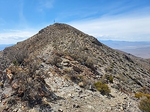
This hike is a gass by DixieFlyer  Gass Peak (elevation of 6,943 feet and prominence of 2,023 feet) is in the Desert National Wildlife Refuge(DNWR), which is about 30 miles north of Las Vegas. The DNWR encompasses 1.6 million acres and it is the largest wildlife refuge in the continental United States. History Gass Peak is named for Octavius Decatur Gass (1828-1924), who is known as the "Father of Las Vegas". Gass settled in present-day Las Vegas in the 1860s; at the time it was part of Mohave County in the Arizona Territory. In 1865 Gass was elected to the lower house in the Arizona Territorial Legislature, and he was able to use his influence to create Pah-Ute County from the northern part of Mohave County. Alas, in 1867 the United States Congress transferred much of Pah-Ute County to Nevada. Despite this, Gass continued to represent Pah-Ute County in the Arizona Territorial Legislature for another 3 years even though he was living in Nevada.
Hike The hike begins and ends at the Gass Peak Trailhead. The hike is on an old roadbed for about 1/4 mile, then continues the rest of the way on a user trail. The trail is well-defined most of the way, although it is a bit faint in a place or two. There is mostly scrub desert vegetation along the way, and you can see Gass Peak almost all the way on the ascent as there is no vegetation tall enough to block your views. It would be difficult to get lost on this hike, although those who are directionally challenged might want to bring a GPS track just to be on the safe side. The trail is very steep in a few places and there are no switchbacks, so many hikers may need to stop for an occasional breather. That is a good excuse to stop and enjoy the scenery anyway. The views at the summit offer quite a contrast: to the north is a vast, remote, and glorious wilderness, while to the south is the Las Vegas sprawl. You'll have a good view of the Spring Mountains to the west, and you can catch a glimpse of Lake Mead to the east. Return to the trailhead the way that you came. It can get very hot in this area in the summertime, and there is lots of sun exposure. As a result, this hike is best done in the fall or spring. Winter hiking is also possible, although there can be some occasional snow. Check out the Official Route and Triplogs. Note This is a moderately difficult hike. Leave No Trace and +Add a Triplog after your hike to support this local community. | |||||||||||||||||||||||||||||||||||||||||||||||||||||||||||||||||||||||||||||||||||||