Route Editor

| Guide | ♦ | 40 Triplogs | 0 Topics |
details | drive | permit | forecast | route |
stats |
photos | triplogs | topics | location |
| 313 | 40 | 0 |
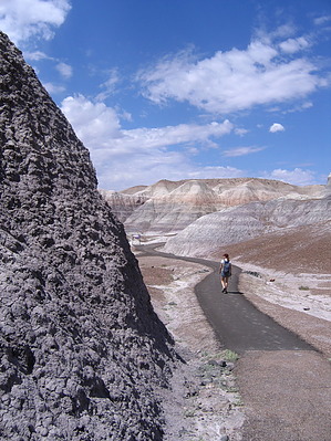
Hike through Blue Badlands by rally_toad   Overview OverviewThe Blue Mesa area of Petrified Forest National Park is a very beautiful and scenic part of the park. It takes a hike through some very cool examples of badlands and offers excellent views of the Blue Palette of the Painted Desert. You can also see a lot of Petrified Wood on this hike and in the Blue Mesa area. Warning I cannot emphasize this enough. Do not collect Petrified Wood or other resources from the park. I want there to be Petrified Wood still here when I come to visit with my grandkids.
Hike Start your challenging hike from the parking area. A shade house on the left has signage about the trail and information about the park. You have good views of the Painted Desert, and from here, you can probably see people on the trail below you. The trail descends off the Mesa and into the badlands below. Still, on the mesa top, you will pass through excellent examples of conglomerate rock. A conglomerate is so named because it comprises many other types of rocks (just like a conglomerate of the business world is made of several different smaller businesses). This rock is cool because you can see the smaller rocks and pebbles that make up the whole thing. You begin the descent and get some good views of cracks forming in the badlands created by running water after and during rain. You will also see a good example of a chimney just off the trail to the right. A chimney is a large hole that you don't want to fall in that forms in many of the badlands hills. If you fall in one when you are by yourself, you will have some trouble getting out. You finally reach the bottom and come to the loop part of the hike, turn right and hike the loop. You get great views of the bentonite clay hills and will see some Petrified Wood as well. Somewhere around the Blue Mesa area are the dying fields, where vertebrate fossils from the Triassic period abound. However, I will not post its exact location online. After you finish the loop, you come to the point when you must start climbing. This is why park staff will tell you that this hike is "moderately strenuous". Run up the hill, return to your car, and go enjoy the rest of the park.
Check out the Official Route and Triplogs. Leave No Trace and +Add a Triplog after your hike to support this local community. | ||||||||||||||||||||||||||||||||||||||||||||||||||||||||||||||||||||||||||||||||||||||||||||||||||||||||||||||||||||||||||||||||||||||||||||||||||||||||||||||||||||||||||||||||