Route Editor

| Guide | ♦ | 1 Triplog | 0 Topics |
details | drive | permit | forecast | route |
stats |
photos | triplog | topics | location |
| 0 | 1 | 0 |
The Center of the World by DixieFlyer  Mount Pinos (elevation of 8,831 feet and prominence of 4,800 feet) is in southern California -- north of Los Angeles and south of Bakersfield. Mount Pinos has a few superlatives that are of interest to peakbaggers: it is the 66th most prominent peak in the continental U.S.; it is a California County highpoint (Ventura County); it is a mountain range highpoint (the San Emigdio Range), and it is a national forest highpoint. History Mount Pinos is in an area that was once part of the Chumash Indian territory. The Chumash once numbered in the tens of thousands and they inhabited much of the California coast. The Chumash referred to Mount Pinos as Iwihinmu, and to them, it was the focal point of the balance of nature. They called the summit Liyikshup, the center of the world.
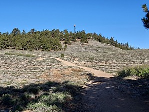
The hike to Mount Pinos is not much more than a walk in the park, particularly given the prominence of the peak. The hike is on a wide, old roadbed that mostly has a smooth tread. There is some elevation gain, but the grade is relatively modest. From the trailhead, you'll stay on the easy-to-follow trail to the summit. Much of the way is at least partially shaded by large pine trees -- mostly Jeffrey Pine. There are some open areas along the way that offer some nice views. About 300 feet or so from the summit, a nice spur trail leads off to the right and goes to the summit. The summit has a microwave tower on it, and it has some nice views to the east. There are a couple of nice overlooks to the west of the summit worth checking out. Adventurous and fit hikers might wish to take the Tumamait Trail just west of Mount Pinos, and continue to Sawmill Mountain (8,818'), the highpoint of Kern County, CA. The hike to Sawmill Mountain enters into the Chumash Wilderness and would add about 4 miles and 1,000 feet of accumulated elevation gain to the hike. With the high elevation, temperatures are moderate on the hike in the summertime. Mount Pinos gets a few feet of snow in the wintertime, and during times of heavy snow, the road to the trailhead might be gated shut. Red Tape The trailhead is at the Mount Pinos Nordic Base, which is a cross-country ski area in the wintertime. During the wintertime you'll need an Adventure Pass or an Interagency Pass to park there; however, at other times of the year, no fee is charged. Gate Policy: If a gate is closed upon arrival, leave it closed after you go through. If it is open, leave it open. Leaving a closed gate open may put cattle in danger. Closing an open gate may cut them off from water. Please be respectful, leave gates as found. The exception is signage on the gate directing you otherwise. Check out the Official Route and Triplog. Leave No Trace and +Add a Triplog after your hike to support this local community. | |||||||||||||||||||||||||||||||||||||||||||||||||||||||||||||||||||||||||||||||||||||