username
X
password
register
for free!
help
 This is likely a great time to hike this trail!  Check out "Preferred" months below, keep in mind this is an estimate.
 

Twin Sisters via Continental Divide Trail, NM

Guide 2 Triplogs  0 Topics
  3 of 5  
Fav
Wish
0
details
drive
no permit
forecast
route  
stats
photos
triplogs
topics
location
10 2 0
Statistics
tap row or icons for details
Difficulty 1 of 5
Route Finding 1 of 5
Distance One Way 4.55 miles
Trailhead Elevation 6,807 feet
Elevation Gain 1,290 feet
Accumulated Gain 2,000 feet
Avg Time One Way 4 hours
Kokopelli Seeds 11.22
 Backpack Yes
unreported if dogs are allowed
editedit > ops > dogs to adjust
feature photo
Photos Viewed All MineFollowing
Inaugural Calculation on Button Tap!
10  2022-05-12 Yoder
Author
author avatar Guides 8
Routes 70
Photos 3,208
Trips 273 map ( 2,155 miles )
Age 59 Male Gender
Location Chandler, AZ
Associated Areas
list map done
Southwest Region
Historical Weather
Trailhead Forecast
Radar Map
Expand Map
Preferred Mar, Apr, Sep, Oct → 7 AM
Sun  5:50am - 6:33pm
Official Route
 
0 Alternative


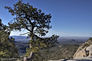
in the midst of relative summits
by Yoder

 Likely In-Season!
Overview
This is a short segment of the Continental Divide Trail to a nice overlook between two peaks (Twin Sisters)


As with most hikes in the forest, there isn't a lot of opportunity to get really good views, but your destination has a great view that makes the hike worth the effort.
remove free decal offer
Hike
Most of this trail has a pretty good grade going between 10-16%, but there are some segments where it levels out. Since this is part of the Continental Divide trail, it is well-traveled and easy to follow. Parts of this trail appear to follow an old road.

Follow the main trail for most of this hike. At about 4.3 miles in the hike, there is an unmarked trail that heads up the side of the mountain. The trail up the mountain is quite steep (30% grade) but only about 0.13 miles. Once up this section, you will find yourself between the Twin Sisters, with a great view of the area.

2022-06-08 Yoder


    Check out the Official Route and Triplogs.
    Leave No Trace and +Add a Triplog after your hike to support this local community.

    One-Way Notice
    This hike is listed as One-Way.

    When hiking several trails on a single "hike", log it with a generic name that describes the hike. Then link the trails traveled, check out the example.
    WARNING! Hiking and outdoor related sports can be dangerous. Be responsible and prepare for the trip. Study the area you are entering and plan accordingly. Dress for the current and unexpected weather changes. Take plenty of water. Never go alone. Make an itinerary with your plan(s), route(s), destination(s) and expected return time. Give your itinerary to trusted family and/or friends.

     Permit $$
    None


     Directions
    or
     Road
    Paved - Car Okay

    To hike
    Trailhead parking is about 10 miles out of Silver City. From Silver City Take Highway 15 North and take turn off to the Interpretive Site (dirt road). There is parking here.
    page created by Yoder on Jun 08 2022 4:16 am
     90+° 8am - 6pm kills
    helpcorrectionissue

    end of page marker