Route Editor

| Guide | ♦ | 2 Triplogs | 0 Topics |
details | drive | permit | forecast | route |
stats |
photos | triplogs | topics | location |
| 28 | 2 | 0 |
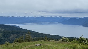
steep and sweet by LindaAnn Hike: Starting from the Maiden Rock Trailhead, head northeast on Talache-Blacktail Trail #117. The uphill starts immediately, not giving you a chance to warm up your legs. The trail is in generally good condition, but rocky in places as you make your way up the relentless switchbacks and elevation gain. You can hear Maiden Creek flowing below you to your left for about the first half-mile, but it stays hidden from view as you climb, winding your way through the forest. There are some trail reroutes on the ascent, but staying on the wider, somewhat less steep trail will keep you on the newer path.
After the highpoint, the trail continues north and starts to gently descend the north face of Butler Mountain. The gentle descent will turn into a steeper descent as you wind your way downhill. Eventually, Peak 4326 will come into view ahead of you and is easily noticed since there are very few trees on the peak, it is nearly bare. Near the bottom of the descent, at a small rise, the trail very noticeably splits. Turn left at this junction and continue north towards the peak. After dropping another 50' or so to the saddle, the trail starts to climb steeply on its final approach to the peak, gaining nearly 300' in less than a quarter-mile. The trail surface on this final ascent is rather poor--mostly baseball-sized rocks. Just below the top, the trail splits again--stay on the right fork and continue uphill. Topping out, you'll see you're on somewhat of a false summit as the true summit is just ahead of you, maybe a hundred feet away. It's a quick walk over to the true summit, where you can rest and enjoy the incredible views in all directions. After soaking in the views, retrace your steps back down, using caution on the rocky section of trail coming off the peak. Once you've climbed back up the north face of Butler Mountain, the rest of the hike is reasonably easy, although the steep descent back to the trailhead can be somewhat tedious. As for all hikes in this region, bring bug spray in the summer. Check out the Official Route and Triplogs. Leave No Trace and +Add a Triplog after your hike to support this local community. | ||||||||||||||||||||||||||||||||||||||||||||||||||||||||||||||||||||||||||||||||||||||