The trail heads south from the Myrtle Creek trailhead and is paved until the bridge. Easy walking as the trail heads into the trees. A large bridge crosses Myrtle Creek and the trail starts to head uphill after the bridge. It's a pleasant hike uphill through the trees.
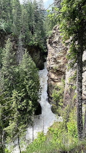
You'll hear the falls as you approach them after less than half a mile of hiking. There are two viewing platforms about twenty feet apart. The lower platform to the left has somewhat obscured views of the falls dropping dramatically between rock walls. The upper viewing area to the right at the metal bench has better views.
remove free decal offer
The trail officially ends at this viewing area, but there is a use-trail leading uphill behind the bench. This trail is steep, slippery, and narrow, but it does lead above the falls for some views of the creek after about a quarter-mile. It's a tough call as to whether the creek views above are worth the effort, but some might enjoy the extra bit of hiking.
Once you've had your fill of viewing the falls, retrace your steps back down to the trailhead.
WARNING! Hiking and outdoor related sports can be dangerous. Be responsible and prepare for the trip. Study the area you are entering and plan accordingly. Dress for the current and unexpected weather changes. Take plenty of water. Never go alone. Make an itinerary with your plan(s), route(s), destination(s) and expected return time. Give your itinerary to trusted family and/or friends.
Permit $$
None
Directions
Road
Paved - Car Okay
To hike From Sandpoint, take US-2/95 north for approx 31 to Bonners Ferry. Turn left on Pine Island Rd (directly in front of the Ranger Station). Pine Island Rd runs in front of the ranger station and around the north side of it, heading west. Take Pine Island Rd west for about 0.20 miles to County Rd 18/Mirror Lake Rd. Turn right on County Rd 18/Mirror Lake Rd and head north for 1.60 miles to Riverside St. Turn left on Riverside St and take west for 4 miles to Westside Rd. Veer right on Westside Rd and the trailhead will be just past this intersection on the left side of the road.
 Route Editor