Route Editor

| Guide | ♦ | 3 Triplogs | 0 Topics |
details | drive | no permit | forecast | 🔥 route |
stats |
photos | triplogs | topics | location |
| 51 | 3 | 0 |
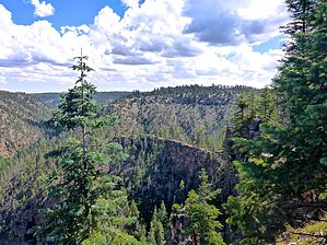
The Sound of Distant Thunder by kingsnake   Overview OverviewLarson Ridge is located in the Apache-Sitgreaves National Forest, on the Mogollon Rim, one mile west of the hamlet of Forest Lakes. Horse Trap Canyon forms its west flank; Larson Canyon the east. I'm not sure if Larson Ridge extends south of AZ-260, but its northern tip ends 7½ miles later at the confluence of Larson Canyon and Chevelon Canyon. FR 237 extends the length of Larson Ridge, with various decommissioned jeep trails branching off it. Description FR 237 is easily car drivable along Larson Ridge, for 6½ miles from AZ-260 to the “No Motor Vehicles” barriers on Hill 7398. Because 14½ miles round trip is a long way to hike, the good surface of FR 237 means you can drive as far down the dirt road as you need to for a hike that matches your endurance. The mild surface and elevation changes mean that casual hikers more comfortable with strolling a Phoenix canal can also enjoy the journey along Larson Ridge.
From Larson Ridge Trailhead, continue north on FR 237. In 200 yds., FR 237 exits the forest, passes through a cleared powerline right-of-way, then re-enters the woods. In ⅓ mile, FR 237 again exits the forest, this time-traveling under the high-tension lines for ½ mile. Heading cross country -- on foot, to avoid MTB tires chewing up the forest floor -- would not be difficult at all: Even by pine forest standards, Larson Ridge is relatively open and free of underbrush. About 6½ miles down Larson Ridge, on top of Hill 7398, FR 237 seems to split. Stay right, passing around the blocking boulders. The descent north from Hill 7398 is not only steep (12%) but rocky, with several step-ups that are strictly for strong mountain bike riders. At least it is easy to hike. There's a final rocky 30 ft. climb to knob at the north end of Larson Ridge. To the right, down and across a relatively flat area, is a hairy razorback ridge, that looks like it is only a few feet across. (Supposedly, this can be used to access the bottom of Chevelon Canyon.) There's an OP straight ahead, but the easier-to-access OPs are to the left. I marked the best OP on the attached GPS route: When you reach the turnaround at the end of FR 237, head left towards the triangle-shaped point with a flat outcropping. Drop into the notch to its left, aiming at the single small pine tree. Wrap around a few feet to the right. It's narrow, but not too bad. You can rest against the upslope boulder you wrapped around or, like I did, step across the narrow slot to the final sharp-scooped rock. The view is fantastic! Check out the Official Route and Triplogs. Leave No Trace and +Add a Triplog after your hike to support this local community. | ||||||||||||||||||||||||||||||||||||||||||||||||||||||||||||||||||||||||||||||||||||||||||||||||||||||||||||||||||||||||||||||||||||||||||||||||||||||||||||||||||||||||||||||||||||||||||||||||||