Route Editor

| Guide | ♦ | 2 Triplogs | 0 Topics |
details | drive | no permit | forecast | route |
stats |
photos | triplogs | topics | location |
| 9 | 2 | 0 |
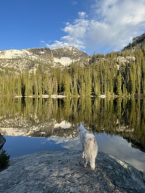
The icing on the cake by FOTG Baker Lake is a popular destination in the Bitterroot Mountains and the jumping off point for the popular mountaineer's route up Trapper Peak. The short but semi-vigorous hike is suitable for families and popular among hikers, backpackers, anglers, and peak baggers. Getting There The Baker Lake trailhead sits at the end of a nine-mile, winding, climbing dirt road that offers some excellent views into the Bitterroots and surrounding country. The road is suitable for all vehicles and is accessible from the well-known West Fork Road, located south of Darby, Montana. There are no facilities at the signed trailhead and there is room for approximately 10 vehicles.
From the parking lot, walk towards the informational kiosk and begin your hike. The trail begins a steady climb on good trail nearly right from the start. The manageable grade pretty much persists for the entire hike, with just a few brief sections of steeper hiking. The forest along the trail shows no signs of recent burns, and as a result, the trail seems to stay in pretty good shape, which may also be a product of it being such a popular destination. After only a few tenths of a mile up the trail, you reach the rock outcropping of Baker Point, which offers some nice views and potential for photos. From there, the trail continues its consistent climb before slightly flattening out for a quarter mile or so, as the trail begins to traverse into Baker Lake. As you reach the lake, social trails spread from the main trail; some head to cross the outlet stream, and others go to various spots along the northeast shore of the lake. Trapper Peak, the highest peak in the Bitterroots, is the mountain that dominates over the lake and encompasses most of its backdrop. The lake is popular. Therefore, expect to run into backpackers and hikers on just about any summer day. For a little more adventure, one can continue to Middle and Gem Lakes via primitive use-trails and off-trail travel. When finished at the lake, return the way you hiked in. Check out the Official Route and Triplogs. Leave No Trace and +Add a Triplog after your hike to support this local community. | |||||||||||||||||||||||||||||||||||||||||||||||||||||||||||||||||||||||||||||||||||||||||