Route Editor

| Guide | ♦ | 1 Triplog | 0 Topics |
details | drive | no permit | forecast | route |
stats |
photos | triplog | topics | location |
| 8 | 1 | 0 |
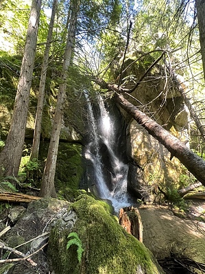
Snowshoes Optional by FOTG Twice in 1805 and 1806 Lewis and Clark traveled and mapped this area. Their purpose was to communicate with the Indians, explore the land and establish the claim of the United States to the vast Pacific Northwest. There is no evidence that anyone in the Corps of Discovery visited Snowshoe Falls, as they were toiling away on the ridges and highpoints to the Northwest of the falls when they passed through here, as the Lochsa River was most likely viewed as unnavigable to the Corps of Discovery. The overland portion of the expedition through this area is said to represent the most difficult times of the entire expedition. Overview The start of this quick hike is easy to miss. The trail is located on the opposite side of the road of the Big Stew Creek pullout, between mile markers 117-118. There is no kiosk, informational board, or register for the trail. A trail sign marks the beginning of the trail on the opposite side of the road. The well-maintained trail immediately begins climbing the steep hillside next to the road and then a series of switchbacks takes you the rest of the way through the brief steep beginning of the trail. The trail levels out after about a quarter of a mile and then you begin the short hillside traverse over to the falls. A signed junction points the way. There is a footbridge at the falls and they are signed. After enjoying the quaint falls and your surroundings, return the way you came.
Check out the Official Route and Triplog. Leave No Trace and +Add a Triplog after your hike to support this local community. | |||||||||||||||||||||||||||||||||||||||||||||||||||||||||||||||||||||||||||||||||||||||||