 Route Editor

| Guide | ♦ | 5 Triplogs | 0 Topics |
details | drive | permit | forecast | route |
stats |
photos | triplogs | topics | location |
| 42 | 5 | 0 |
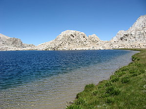
A Litttle Used Trail Right Next to Mount Whitney by Jim Quota: While trails in the Whitney Zone require a permit for day hiking, the Meysan Lake Trail and all other trails in the Inyo National Forest do not require a permit for day use. This is great because it allows a Whitney Permit holder to easily hike the trail before or after a Whitney climb, or if denied a walk-up permit for Whitney it makes for a nice hike instead of the Whitney Trail. If you plan to overnight, the quota is set at 10 people entering per day. There are 6 reservable spots and 4 walk-in spots. Odds are, you won't have any trouble getting an overnight permit. I walked in to the permit office and was able to get a same day entry permit on a Friday in August. When I arrived at Meysan Lake, only 4 other people had entered that day. It is not a busy area. When those people left Sunday morning, I had the lake and possibly the entire basin to myself as I saw no other tents at the other lakes along the trail. I only encountered 1 day hiker while I was leaving the basin Monday at midday.
Vegetation on the trail is typical for the dry south eastern high Sierra Nevada. You start out in mixed Jeffrey Pine, White Fir, Single-Leaf Pinyon Pine and Mountain Mahogany. As you climb, Limber Pine, Foxtail Pine and Willows the along wet areas replace the lower elevation trees. Eventually, the tress will disappear and only small alpine plants will be found amongst moraine. At this point you will find yourself overlooking Meysan Lake. Because the area is dry and on a south face, the cover is open, and it is very sunny. You might find the area below 10,000' to be hotter than expected due to the sun. You will definitely want a hat or something to protect yourself from the sun, which seems to be omnipresent on this high elevation hike. After leaving the campground, there is no easily accessed perennial water until Grass Lake at the 4 mile point. Camping: While this is a great day hike, it is also a great place to overnight as a backpacking trip, or if you plan to climb any of the peaks which are accessed from the basin. A few of these peaks are Lone Pine Peak, Mount Mallory, Mount Irvine, and Mount Le Conte. They all require a little route finding, but are not out of the realm of possibility for inclusion into an overnight trip on the trail. Overnight camping can be found at any of the lakes which are encountered after 4 miles on the trail. The first lake is Grass Lake, next is Camp Lake, and last is Meysan Lake. Both of these lakes are on the small side, but they provide water and a place to camp. I prefer Meysan Lake. Meysan Lake is an alpine lake high in the basin and at the foot of Mount Irvine and Mount Mallory; both mountains were named for two mountaineers who died while trying to summit Mount Everest in the 1920s. The lake sits at 11,474' and is fed by snow melt. There are numerous camp sites situated on some cliff above it on the north side, on a sandy beach on the south side, and in the glacial carved outflow area near the rim of the cirque that hold the lake. The lake makes an ideal place to camp if you plan to climb any of the peaks that ring the basin. If you are especially brave, you can swim in Meysan Lake. I spent about 5 seconds under the water, and coming out felt much better than going in. Solitude: If you choose to hike this trail, you might have a hard time believing you are only a short distance from the Whitney Trail. As apposed to 160 people per day, you will have substantially fewer, and might only encounter 1 or 2 people on your trip. This basin really does offer a much better wilderness experience for being where it is. If you still want to see it, a few of the peaks that ring the basin offer great views of Whitney and the Whitney Zone. Gate Policy: If a gate is closed upon arrival, leave it closed after you go through. If it is open, leave it open. Leaving a closed gate open may put cattle in danger. Closing an open gate may cut them off from water. Please be respectful, leave gates as found. The exception is signage on the gate directing you otherwise. Check out the Official Route and Triplogs. Leave No Trace and +Add a Triplog after your hike to support this local community. One-Way Notice This hike is listed as One-Way. When hiking several trails on a single "hike", log it with a generic name that describes the hike. Then link the trails traveled, check out the example. | ||||||||||||||||||||||||||||||||||||||||||||||||||||||||||||||||||||||||||||||||||||||||||||||||


