 Route Editor

| Guide | 0 Triplogs | 0 Topics |
details | drive | no permit | forecast | 🔥 route |
stats |
photos | triplogs | topics | location |
| 0 | 0 | 0 |
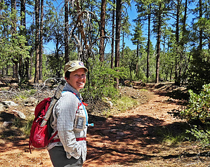
Join the AZT by Sredfield  Overview OverviewA quick 1.5-mile access route along Bray Creek to the Arizona Trail. Hike FR 439 is a rough two-track trail extending 1.2 miles north from the Control Road. It ends at a locked gate where the route begins. Continue on the now-rougher two-track road a half-mile to a signed trail on the right. The trail climbs a short distance around private land and buildings, then levels out before more ups and downs. The intermittent stream in the canyon bottom to the left is a tributary of Bray Creek. The trail drops and crosses this stream, then passes a trail junction and a sign noting the private land to the left. From this location the trail is less pronounced; watch for small cairns. Where it veers left it soon drops under the tall pine trees to Bray Creek, crosses the creek, and turns north before joining the AZT. Gate Policy: If a gate is closed upon arrival, leave it closed after you go through. If it is open, leave it open. Leaving a closed gate open may put cattle in danger. Closing an open gate may cut them off from water. Please be respectful, leave gates as found. The exception is signage on the gate directing you otherwise. Check out the Official Route. Leave No Trace and +Add a Triplog after your hike to support this local community. One-Way Notice This hike is listed as One-Way. When hiking several trails on a single "hike", log it with a generic name that describes the hike. Then link the trails traveled, check out the example. | ||||||||||||||||||||||||||||||||||||||||||||||||||||||||||||||||||||||||||||||||||||||||||||||


