username
X
password
register
for free!
help
 This is likely a great time to hike this trail!  Check out "Preferred" months below, keep in mind this is an estimate. 
  

Red Lake Peak, CA

Guide 5 Triplogs  0 Topics
  4 of 5  
Fav
Wish
0
details
drive
permit
forecast
route  
stats
photos
triplogs
topics
location
13 5 0
Statistics
tap row or icons for details
Difficulty 3.5 of 5
Distance One Way 1.52 miles
Trailhead Elevation 8,569 feet
Elevation Gain 1,521 feet
Accumulated Gain 1,574 feet
Kokopelli Seeds 6.77
 Interest Off-Trail Hiking & Peak
unreported if dogs are allowed
editedit > ops > dogs to adjust
feature photo
Photos Viewed All MineFollowing
Inaugural Calculation on Button Tap!
3  2025-05-12 toddak
2  2023-05-29 toddak
8  2022-08-06 toddak
Author
author avatar Guides 595
Routes 0
Photos 0
Trips 247 map ( 429 miles )
Age ?
Location
Associated Areas
list map done
Sierra Nevada Region
Historical Weather
Trailhead Forecast
Radar Map
Expand Map
Preferred Sep, Jun, Aug, Jul
Sun  5:32am - 6:24pm
Official Route
 
0 Alternative


remove free decal offer

 Likely In-Season! 
Guide Needed
Publish Full Detail Guide


Use +Add above to share photos and triplogs
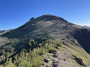
Solid climb to the 10,068' summit of Red Lake Peak mostly on good peakbagger trail to great views of Lake Tahoe, Mokelumne Wildernes, etc. In 1844 John C. Fremont climbed the peak as he crossed the Sierras.


    Check out the Official Route and Triplogs.
    Leave No Trace and +Add a Triplog after your hike to support this local community.

    One-Way Notice
    This hike is listed as One-Way.

    When hiking several trails on a single "hike", log it with a generic name that describes the hike. Then link the trails traveled, check out the example.
    WARNING! Hiking and outdoor related sports can be dangerous. Be responsible and prepare for the trip. Study the area you are entering and plan accordingly. Dress for the current and unexpected weather changes. Take plenty of water. Never go alone. Make an itinerary with your plan(s), route(s), destination(s) and expected return time. Give your itinerary to trusted family and/or friends.

     Permit $$
    Information is listed below


     Directions
    or
     Road
    Paved - Car Okay

    To hike
    Park at Meiss Trailhead on Highway 88 at Carson Pass. $5 parking pass required (cash only).
    page created by toddak on Aug 08 2022 3:34 pm
     90+° 8am - 6pm kills
    helpcorrectionissue

    end of page marker