Route Editor

| Guide | ♦ | 6 Triplogs | 0 Topics |
details | drive | no permit | forecast | route |
stats |
photos | triplogs | topics | location |
| 159 | 6 | 0 |
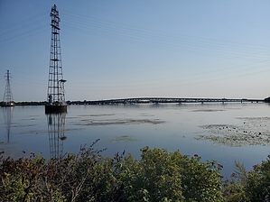
under the bridge, through the woods, and along a peninsula by Mike_W  This hike starts on the North end of Grand Island along the Niagara river, follows the river, and goes out to a peninsula that extends part way out to the Niagara river. The currents are very strong in this area as Niagara falls is only about 3 miles downstream. Warning The currents are very strong here and it would not be a good idea to swim anywhere along this trail. There are a few signs and warnings that indicate this. Niagara falls is only about 3 miles downstream.
From the parking area, walk West and follow a wide trail going into the forest. After about 0.2 miles you will see a clearing and have a better view of the Niagara River to your right. After about 0.5 miles you will walk across a bridge that crosses a stream. This is a popular fishing area. Continue on the trail and after 1.2 miles you will reach the North Grand Island bridge. Walk under the bridge and the trail will curve a bit to the left. Shortly, you'll see a junction. Take the right branch which goes to the West. Follow this trail until you have traveled roughly 1.9 miles. You will see a small short trail that goes straight to the water, with a clearing. There is a metal mailbox here in a tree that contains a registry. If you instead turn to the right, you can continue for 1/4 mile further or less to the end of the peninsula. From this point, looking West you can see the mist of Niagara Falls, looking North across the water is the city of Niagara Falls, looking East you will see the Grand Island bridge that goes North to Niagara Falls. To return, take the trail back the entire way that you came, or for a nice loop, pass the Grand Island bridge on the way back and stay to your right. The path follows the highway for almost 1/2 mile and then there is a trail heading East to a parking area. This is another possible place to park. Keep following the trail and you will reach a road. Walk the shoulder of the road back to where you parked to complete the loop. About 1/4 from the endpoint, there's another parking area on the North side of East West Park Road (also known as River Road). Check out the Official Route and Triplogs. Leave No Trace and +Add a Triplog after your hike to support this local community. | |||||||||||||||||||||||||||||||||||||||||||||||||||||||||||||||||||||||||||||||||||||||||