Route Editor

| Guide | ♦ | 3 Triplogs | 0 Topics |
details | drive | no permit | forecast | route |
stats |
photos | triplogs | topics | location |
| 122 | 3 | 0 |
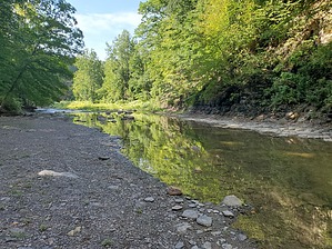
a little less than 18 miles by Mike_W Eighteen Mile Creek Park (Erie County) is located about 15 miles South of the city of Buffalo, New York. There are 2 branches of the 18-mile creek (North and South) that merge and flow into Lake Erie to the West. The park is made up of 466 acres of land which is approximately 3/4 of 1 square mile. There are a few trails that follow the East rim of both creek branches. It's also possible to walk in the creek bed below when the water level is low and also hike a loop involving the creek bed and rim. Hike From the parking lot on South Creek road, follow the trail about 1/4 mile to the West. At this point, you will see a trail heading down to the North branch of the creek which is only about 75 feet below. Take this branch to head down to the creek. Once near the bottom, the trail follows the creek for a while and appears to drop off into the creek. I found a small pool ladder near the bottom which others have used to get down a short steep part of the trail. If the water level is not high, it should be possible to walk along the edge without crossing the stream. Continue until you have traveled about 1.25 miles and you should be at a 3-way junction in the stream. If you take the left branch, you will be on the South branch of the creek; if you take the right branch, you will be on the main branch of the creek. Taking the main branch, there is a short section of trail that ends at North Creek road. Take the left branch which is the South branch of the creek. After you have hiked a total of roughly 2 miles, you will see a trail that climbs out of the creek and up to the North rim. Take this trail up and continue West to loop back toward the starting point. After another 1/2 mile, the trail will turn to go around a small stream and there may be a good photo opportunity in this area of a small waterfall. Continue taking the trail and eventually, you will see the branch that you took earlier to go down to the creek. Stay straight and in another 1/4 mile, you will be back at the parking area.
Ruins I found 2 chimney structures that were in the woods, off the trail, within the first 1/4 of the trail, and just South of the trail. I didn't see any signs and the forest was fairly thick here so I didn't take the time to explore these ruins. Check out the Official Route and Triplogs. Leave No Trace and +Add a Triplog after your hike to support this local community. | ||||||||||||||||||||||||||||||||||||||||||||||||||||||||||||||||||||||||||||||||||||||||