Route Editor

| Guide | ♦ | 1 Triplog | 0 Topics |
details | drive | no permit | forecast | route |
stats |
photos | triplog | topics | location |
| 65 | 1 | 0 |
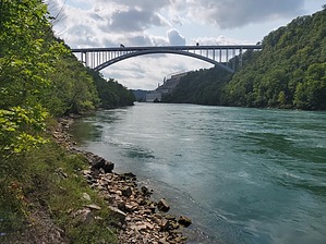
Living on the Edge by Mike_W  The Whirlpool Rapids are rated 6 on a navigatable scale from 1 (easiest) to 6 (most dangerous). Whirlpool Rapids at White Water Walk are traveling at about 48km/hr or 30mph, creating the Whirlpool Rapids - "Class 6 white-water rapids". The Whirlpool Rapids consists of 4 kilometers of 3-5 meter standing waves, making this stretch of whitewater the largest/finest series of standing waves in North America. Note Devil's Hole state park is roughly 4 miles downstream from Niagara Falls. Stairs go down to a lower level here and a nice trail that follows the Niagara river and Whirlpool Rapids area. See my guide for Whirlpool Trail for more information on the trails to the South.
The trail going from Devil's Hole State Park to Artpark is made up of a series of roads, paths and trails. The loop goes past Niagara University, the Niagara Power Authority, then down into the town of Lewiston, through Art Park State Park, then to the shore of the Niagara River and rapids area, then along the river, and eventually back up to link up with the upper rim trail. Hike Start by walking North and East to the main trail which is the Niagara Gorge Rim Trail (#2). This follows the Niagara Scenic Parkway and stays on the upper rim for roughly the first 2 miles. After 1/2 mile you will see Niagara University to the East. Continue for another 1/4 mile and you will see the Niagara Power Authority to your left. Immediately North of the Power Authority, there will be a trail heading Northwest and it will be easy to pass this junction without seeing it as it is rather hidden. This is the trail I came back on this long loop. For a shorter loop, you might consider taking this trail and turning around at any point. For a longer loop, continue straight. After a total of roughly 2 miles, you will see a junction and the Niagara Gorge Trail (#9) heading left. As of September 2022, this trail was blocked off for maintenance. Continue on the paved path which follows the Parkway. After a total of 3 miles from your starting point, this trail will make a U-turn and continue into Artpark State Park. I walked through the park, around the amphitheater, and then down toward the lower parking lot. Next, I saw a clearing and walked West through part of the park and down some stairs to the shoreline. Then followed a trail heading South for a while. I found another staircase and took that up to the River's Edge Trail (#8). Next, I followed the River's Edge trail for at least 1 mile before it went under the Lewiston Queenston Bridge going to Canada. During this 1 mile stretch, there are a few lookouts that go down to the river. The water flow in all of these areas is fast so please be cautious. Swimming is off-limits here. There is a strong undercurrent and the water is moving much faster than it looks. There are also whirlpools and dangerous rocks under the water. Very close to the bridge the River's Edge trail (#8) climbs up the gorge to the higher level trail which is called the Artpark Gorge Trail (#7). There's an unnamed branch of the trail that continues on the lower level, near the shore for about 1/3 mile. I took this trail until it appeared to end and turned around to go back to the junction. If you would like to shorten your hike, you can skip this section. Just head up the River's Edge trail (#8) and take that roughly 0.5 to 1 mile back to the Niagara Gorge Rim Trail (#2). Continue along this trail to get back to Devil's Hole State Park and the parking area. Check out the Official Route and Triplog. Leave No Trace and +Add a Triplog after your hike to support this local community. | ||||||||||||||||||||||||||||||||||||||||||||||||||||||||||||||||||||||||||||||||||||||||||||