username
X
password
register
for free!
help
  

Trona Pinnacles, CA

Guide 2 Triplogs  0 Topics
  2 of 5  
Fav
Wish
0
details
drive
permit
forecast
map
stats
photos
triplogs
topics
location
30 2 0
Statistics
tap row or icons for details
Distance One Way 0 miles
Trailhead Elevation 1,810 feet
unreported if dogs are allowed
editedit > ops > dogs to adjust
feature photo
Photos Viewed All MineFollowing
5  2024-05-08 slegal
15  2017-03-26 RedRoxx44
4  2012-06-19 keepmoving
6  2009-08-06 Randal_Schulhaus
Author
author avatar Guides 16,843
Routes 17,472
Photos 24
Trips 1 map ( 6 miles )
Age 28 Male Gender
Location HAZ, TrailDEX
Associated Areas
list map done
Central Valley Region
Historical Weather
Trailhead Forecast
Expand Map
Preferred Nov, Feb, Mar, Jan
Sun  5:24am - 6:13pm
0 Route
 
0 Alternative


remove free decal offer

Area: However it may appear to you, a visit to the Trona Pinnacles will be a journey into one of the most unusual geologic wonders in the California Desert. This unique landscape consists of more than 500 tufa (calcium carbonate) pinnacles rising from the bed of the Searles Dry Lake basin. These tufa spires, some as high as 140 feet, were formed underwater 10,000 to 100,000 years ago when Searles Lake formed a link in an interconnected chain of Pleistocene lakes stretching from Mono Lake to Death Valley.


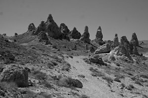
The Trona Pinnacles were designated by the Department of the Interior as a National Natural Landmark in 1968 to protect one of the nation's best examples of tufa formation. The area is managed by the Bureau of Land Management to protect its scenic values and has become a popular filming location for movies and commercials.

2018-07-14 HAZ_Hikebot


    Check out the Triplogs.
    Leave No Trace and +Add a Triplog after your hike to support this local community.

    One-Way Notice
    This hike is listed as One-Way.

    When hiking several trails on a single "hike", log it with a generic name that describes the hike. Then link the trails traveled, check out the example.
    WARNING! Hiking and outdoor related sports can be dangerous. Be responsible and prepare for the trip. Study the area you are entering and plan accordingly. Dress for the current and unexpected weather changes. Take plenty of water. Never go alone. Make an itinerary with your plan(s), route(s), destination(s) and expected return time. Give your itinerary to trusted family and/or friends.

     Permit $$

     Directions
    or
     Road
    FR / Jeep Road - Car possible when dry

    To hike
    GETTING THERE: The Trona Pinnacles are located approximately 20 miles east of Ridgecrest. Access to the site is from a BLM dirt road (RM143) that leaves SR 178, about 7.7 miles east of the intersection of SR 178 and the Trona-Red Mountain Road. The 5-mile long dirt road from SR 178 to the Pinnacles is usually accessible to 2-wheel drive vehicles, however, the road may be closed during the winter months after a heavy rain.
    page created by Randal_Schulhauser on Aug 23 2009 8:22 am
     90+° 8am - 6pm kills
    helpcorrectionissue

    end of page marker