Route Editor

| Guide | ♦ | 1 Triplog | 0 Topics |
details | drive | permit | forecast | route |
stats |
photos | triplog | topics | location |
| 15 | 1 | 0 |
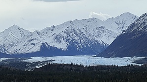
on the edge in the smooth and wide sense by LindaAnn Hike: The trail starts at the south end of the parking area and is signed. There are immediate views of the glacier, mountains, and river. Head east from the signs and up a small rise. The trail is compact dirt, smooth and wide. One of the first signs along the trail points out a rock glacier on the mountain behind you.
Check out the views at each sign, with the best views of the glacier being at the east end of the loop. After that, the loop curves back west, mostly levels off, and is a pleasant walk through the trees, primarily aspen. It's an easy walk to finish out the loop and return to your starting point. Check out the Official Route and Triplog. Leave No Trace and +Add a Triplog after your hike to support this local community. | |||||||||||||||||||||||||||||||||||||||||||||||||||||||||||||||||||||||||||||||||||||||||