Route Editor

| Guide | ♦ | 2 Triplogs | 0 Topics |
details | drive | permit | forecast | route |
stats |
photos | triplogs | topics | location |
| 40 | 2 | 0 |
 Recommended Users: Equestrians, Hikers, Mountain Bikers Two-track and single-track 3.5 miles Difficulty: Moderate/More Difficult (IMBA Trail Difficulty Rating System)
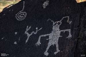
In addition, the remains of a pre-historic Ancestral Puebloan farmstead are visible and interpreted for visitors. The views from Land Hill of the surrounding area are another attraction; the Red Mountains, Snow Canyon State Park, Santa Clara River, and distant Beaver Dam Mountains provide spectacular scenery. From the Anasazi Valley Trailhead, the trail winds upslope for 1.2 miles* to reach the main area of petroglyphs and the Ancestral Puebloan farmstead. The trail continues south beyond the main petroglyph area by way of single-track that hugs the cliff edge. More petroglyphs can be seen here with close observation. An old road is the basis for the next section of the trail as it climbs Land Hill to its highest point. At the last turn-around in the road, the trail dives off the top, returning to single track and following the edge of the rim. Just as the hill moderates, the trail returns to an old road until reaching its end at the intersection of the Upper Graveyard Trail. Take the Upper Graveyard Trail and then the Fishhook Trail to reach the Tukupetsi Trailhead. *The 1.2-mile section of the trail has been damaged by a succession of high rainfall storms but is still open for hiking and mountain biking. Source: BLM Check out the Official Route and Triplogs. Leave No Trace and +Add a Triplog after your hike to support this local community. | |||||||||||||||||||||||||||||||||||||||||||||||||||||||||||||||||||||||||||||||||||||||||||||