Route Editor

| Guide | ♦ | 12 Triplogs | 0 Topics |
details | drive | no permit | forecast | 🔥 route |
stats |
photos | triplogs | topics | location |
| 133 | 12 | 0 |
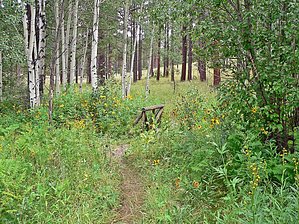
A little bit of everything by HAZ_Hikebot  Hike HikeThis cool, verdant canyon has long been a favorite with tourists. It is particularly popular with seniors and families with young children because of the level grade of the trail and the interpretative stations. Its location in Greer makes it a convenient spot for the many visitors to this picturesque community. The trail travels up Butler Canyon for about one-half mile, then crosses a small stream before looping back. Butler Canyon was named for Jacob Butler, who settled here in the late 1880s with his nineteen children. Aquatic plants grow along the stream, which is shaded by alders and willows. Aspen, pine, spruce, and fir line the canyon and provide nests for the many birds who make their home here. If you start your hike early enough, you may see wild turkeys, deer, and coyotes as they come downcanyon for a drink.
Hikers and bicyclists are welcome, but no horses and no motorized vehicles. Please pack out litter. Water in the creek and spring box is untreated. Please bring your own. This hike is excellent for children. It might be difficult for the elderly because of a slight elevation gain in the beginning. The Butler Canyon Trail is a self-guided nature trail with numbered stations beside the path. These stations correspond to descriptions in a pamphlet that is available at a sign-in station at the trailhead. Please return the pamphlet after you've finished with it so that others may use it. Interpretative lectures and walks are conducted here during the summer by a Forest Service Naturalist. Schedules post at Hoyer Campground and the Springerville Ranger Station. Check out the Official Route and Triplogs. Leave No Trace and +Add a Triplog after your hike to support this local community. | ||||||||||||||||||||||||||||||||||||||||||||||||||||||||||||||||||||||||||||||||||||||||||||||||||||||||||||||||||||||||||||||||||||||||||||||||||||||||||||||||||||||||||||||||||||||