Route Editor

| Guide | ♦ | 1 Triplog | 0 Topics |
details | drive | permit | forecast | route |
stats |
photos | triplog | topics | location |
| 6 | 1 | 0 |
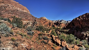
Snow Canyon Loop by Yoder The hike starts at the Edge of Snow Canyon's south entrance and although the toll booth for entering Snow Canyon is beyond the trailhead, this is still a fee area.
On the North side of the saddle, views of the canyon are quite nice, the red and white sandstone make a nice contrast. Continuing along Padre Trail the trail becomes less steep as you proceed until you hit a small section of slick rock then down to the pretty flat ground where the Padre Trail ends and intercepts with the Red Sands trail at about 3.7 miles into the hike. Red Sands Trail is pretty much as the name suggests, following the valley floor until you cross some slick rock hills leading you to the Whiptail "Trail" at about 4.7 miles. Whiptail Trail is more of a paved bike path, although it is advertised as a trail. This bike path is quite popular, so hikers beware as you may get run over. Whiptail parallels the main road through Snow Canyon and eventually ends back at the Johnson Canyon Parking area. Check out the Official Route and Triplog. Leave No Trace and +Add a Triplog after your hike to support this local community. | ||||||||||||||||||||||||||||||||||||||||||||||||||||||||||||||||||||||||||||||||||