Route Editor

| Guide | ♦ | 2 Triplogs | 0 Topics |
details | drive | no permit | forecast | route |
stats |
photos | triplogs | topics | location |
| 46 | 2 | 0 |
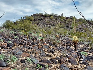
Verde with Envy by DixieFlyer  Overview OverviewThis hike is to the summit of the Palo Verde Hills mountain range highpoint (elevation of 2,172 feet and prominence of 1,012 feet). In deference to its elevation, the unnamed highpoint is marked "2172" on topographic maps. The Palo Verde Hills are a small range in western Maricopa County, near the town of Tonopah. It is about 5 miles southeast of Saddle Mountain - Tonopah.
Indigenous people once lived in the area, and there are reputed to be petroglyphs in the Palo Verde Hills. However, I did not see any glyphs when I did this hike. The Palo Verde Hills is so named because early settlers found many palo verde trees growing in the area. Arizona Place Names Hike This is a very straightforward hike. From the parking spot, the Palo Verde Hills highpoint is clearly visible to the northeast. You will initially walk across the flat desert floor for about 3/4 mile. This is easy walking with sparsely spaced creosote bushes being the only vegetation. You'll then begin gaining some elevation as you traverse around the right side of a knob that you see in front of you. This will take you to a saddle at 1,275 feet of elevation, after hiking 1/2 mile. At this point, you'll have to make a fairly steep ascent up a hillside that is strewn with black basalt rocks and boulders. The climb looks daunting from a distance, but it is not bad. The footing is good, the rocks are generally stable, and there is no vegetation to impede your progress. Just take it a step at a time and the climb will go by quickly. After about 0.3 miles you'll come to another saddle that will give you a bit of a breather before scampering up some other, less steep slopes as you continue on a ridgeline that is southwest from the summit. Before you know it you'll be at the summit, which has a large flat area. The summit cairn has a height-of-light sticking out of it, and there is a summit register log with some recognizable names. There are nice 360-degree views at the summit, most notably of Woolsey Peak to the south and Saddle Mountain to the west. Water Sources Don't count on finding any water out here, except perhaps right after a monsoon rain storm. Camping Disbursed camping is allowed, with a limit of 14 days. Synopsis This hike likely won't make anyone's top 10 list, but it is an enjoyable low-elevation desert hike. There is nothing really difficult about the hike -- there is no bushwhacking, no cliffs to deal with, and nothing really complicated. The geology is not as nice as nearby Saddle Mountain, but if you are in the area and have 3 hours to kill you might want to give this hike a try. If you enjoy solitude, you'll almost certainly find it on this hike. Check out the Official Route and Triplogs. Leave No Trace and +Add a Triplog after your hike to support this local community. | |||||||||||||||||||||||||||||||||||||||||||||||||||||||||||||||||||||||||||||||||||||