 Route Editor

| Guide | ♦ | 2 Triplogs | 0 Topics |
details | drive | permit | forecast | 🔥 route |
stats |
photos | triplogs | topics | location |
| 26 | 2 | 0 |
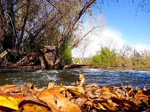
Three Rivers -- without the Pirates by kingsnake  For Maricopa Trail completists, this segment starts at the Estrella Mountain Regional Park competitive mountain bike track. Walk 250 yds. back north on the dirt road, the way you drove in. Continue north on paved Avenida Estrella, through the vast PIR parking lot, until you reach Indian Springs Rd. after ½ mile. Turn east, marveling at PIR's magnificent facade, until you arrive at Monument Hill Trailhead after 1½ miles. Really, you should have started here. For Maricopa Trail completists, this segment starts at the Estrella Mountain Regional Park competitive mountain bike track. Walk 250 yds. back north on the dirt road, the way you drove in. Continue north on paved Avenida Estrella, through the vast PIR parking lot, until you reach Indian Springs Rd. after ½ mile. Turn east, marveling at PIR's magnificent facade, until you arrive at Monument Hill Trailhead after 1½ miles. Really, you should have started here.From the Monument Hill Trailhead, it is 3¾ miles to the Tres Rios Trailhead on 91st Ave. All distances were measured from Monument Hill Trailhead. (Avg. time is one-way from the MTB track.)
If you are a birder, not a hiker, my recommendation is either 1) walk ¼ mile north to the “island” between the Gila River and Salt River, then wander ½ mile out to the east tip of the “island”, or 2) starting at 91st Ave. head west 1½ miles along the North Bank Wetlands Trail, South Bank Wetlands Trail or Maricopa Trail. All three are appropriate for small children, oldsters, and even wheelchairs. All told there are about eight miles of trails in Tres Rios Wetlands. After ½ mile, the Maricopa Trail turns east at the north levee, which it more or less follows for another mile to the west end of the Tres Rios Wetlands. There’s scattered garbage, and not too much to recommend. It would have been nice if the powers that be routed the Maricopa Trail across one of the old jeep trails closer to the Salt River. The 91st Ave. sewage plant provides a daily average of 78 million gallons of treated wastewater to the Salt River and Tres Rios Wetlands, restoring them to their natural 19th-century splendor. This hike first encounters the results upon entering the Phoenix municipal park at 1½ miles. At the split / X-intersection, left onto North Overbank Wetlands trail; right onto South Overbank Wetlands Trail; straight to continue on Maricopa Trail. The main channel of the Salt River is out of sight, to the south. Close by to the north of the Maricopa Trail, for the next 1½ miles is a series of about a dozen small ponds formed by cement check dams at their west end. Though surely a coincidence, the ponds alternate between open water and being covered by pennywort (small “lilypads”). There are 9 or 10 nature signs in the ¾ miles between the Salt River Discharge Structure and 91st Ave. trailhead. The islands north of the trailhead are fenced off and are for official use only. (Though there is an open trail looping around the outside of the fence.) Besides the fauna listed in the Monument Hill guide, flora includes Freemont’s cottonwood, Gooding’s willow, saltbush, cattail, bulrush, giant & alkali sacaton grasses, desert screwbean, mesquite, the usual array of Sonoran desert shrubbery, fan palm and salt cedar. Plus several species of ground-hugging ferns/vines I can't determine. I don’t remember any cacti, though I am sure they were there.
Check out the Official Route and Triplogs. Leave No Trace and +Add a Triplog after your hike to support this local community. One-Way Notice This hike is listed as One-Way. When hiking several trails on a single "hike", log it with a generic name that describes the hike. Then link the trails traveled, check out the example. | ||||||||||||||||||||||||||||||||||||||||||||||||||||||||||||||||||||||||||||||


