Route Editor

| Guide | ♦ | 1 Triplog | 0 Topics |
details | drive | permit | forecast | route |
stats |
photos | triplog | topics | location |
| 22 | 1 | 0 |
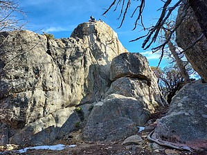
Too hot to handle by DixieFlyer Hot Springs Mountain (elevation of 6,533 feet and prominence of 2,613 feet) is the highpoint of San Diego County. Prologue The hike is entirely on a forest road with very nice tread on it. You'll be hiking on compressed sand and dirt which is compacted enough not to be slippery but provides some cushioning. There is hardly a single rock on the roads. Once at the summit, there is a fun class 3 climb to get to the summit, which is atop a boulder about 20 feet high.
From the campground, begin the hike on Sukat Road at a "Trail Entrance" sign. You will start going uphill almost immediately. The first 2 miles are the toughest part of the hike, as you'll gain about 1,300 feet in that stretch. The tread is very nice which makes for some nice hiking. There is a lot of sun exposure in this section, which might make it uncomfortable on a hot summer day. After about 2.5 miles you'll come to a junction with Hot Springs Mountain Road, which is the only junction on the hike. Take a right turn onto Hot Springs Mountain Road, at a sign that says "Lookout Tower". Continue on Hot Springs Mountain Road all the way to the summit area. The grade lessens quite a bit during this section, and you'll be hiking through a nice coniferous forest. Once at the summit area, you'll see a couple of picnic tables and the remains of the Hot Springs Fire Lookout Tower to your left. The wooden tower was constructed in 1942 and once had a 14X14 cab on it. However, the roof has collapsed, the structure is dilapidated, and it is probably not too far away from falling completely. From the fire lookout tower, head northeast to the highpoint, which is atop a large boulder. There is a metal ladder and some nylon webbing attached to some bolts on the boulder that some use to climb to the highpoint. However, this looked exposed and sketchy to the author of the guide, so he climbed up on the north side of the boulder via a minimally exposed class 3 climb. Those who have a fear of heights or who are uncomfortable with climbing should probably not try and get to the summit. Others will likely find the climb to be a lot of fun! After enjoying the views at the highpoint, return to the trailhead the way that you ascended. Synopsis This was an enjoyable hike on some very nice tread. You will get a decent workout on the hike, along with a fun class 3 climb to get atop the summit boulder. Check out the Official Route and Triplog. Leave No Trace and +Add a Triplog after your hike to support this local community. | |||||||||||||||||||||||||||||||||||||||||||||||||||||||||||||||||||||||||||||||||||||