 Route Editor

| Guide | ♦ | 35 Triplogs | 3 Topics |
details | drive | permit | forecast | route |
stats |
photos | triplogs | topics | location |
| 170 | 35 | 3 |
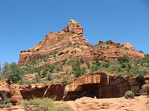
A Glorious Spire by Jim   Introduction IntroductionIf you've done Capitol Butte and you like the scrambling you encountered on that, you might like to try Morning Glory Spire. This small formation sits just off of the Soldiers Pass Trail and is not often climbed since it isn't very tall, or high. It does offer some pretty nice views and is pretty fun. This climb has some great views of Capitol Butte's north face. Approach From the Soldiers Pass Trailhead, take the trail to the large sinkhole known as the Devil's Kitchen. Proceed around the sinkhole and you might see a rappel anchor on the north to the northwest side. Finding it isn't important, but it is neat to see. At this point, you are on the south side of Morning Glory. Continue and climb up over the red sandstone hill and make your way to the north side of the spire. There are some rough trails, but nothing is well defined. It may be helpful to look for the Ocotillo growing on the east side of Morning Glory near its base, and once you have found them, try to climb up and move further to the north.
Climbing Climb up this first pitch of relatively easy 4th class climbing that is about 20 feet in length and take a left towards the summit. There should be a visible climbing trail that will take you where you want to go. Follow it to another small pitch of 3rd class climbing and then proceed to the only hard part of the entire climb, the 4th class pitch which is just left of, or in a small angled chimney. If you go left of it, there are numerous small holds that you will be able to use and a narrow ledge about 2/3 of the way up this pitch. After the difficult section, there is one last pitch of 3rd class climbing that will take you to the summit block. It is small, but you'll enjoy gaining it. Descent is either by the route you came up or using one of the rappel anchors which are on or near the summit. It looked like you would want at least a 60-meter rope to rappel. Pro No protection is needed, including helmets. There are rappel anchors on the summit and just off of it, in case you would rather not down climb.
Check out the Official Route and Triplogs. Leave No Trace and +Add a Triplog after your hike & climb trip to support this local community. | ||||||||||||||||||||||||||||||||||||||||||||||||||||||||||||||||||||||||||||||||||||||||||||||||||||||||||||||||||||||||||||||||||||||||||||||||||||||||||||||||||||||||||||||||||||||||||||||||||||||||||||||||||||


