Picayune Everglades Ranch Trail, FL • Hike
username
X
password
register
for free!
help
 This is likely a great time to hike this trail!  Check out "Preferred" months below, keep in mind this is an estimate.
  

Picayune Everglades Ranch Trail, FL

Guide 1 Triplog  0 Topics
  3 of 5 
Fav
Wish
0
details
drive
permit
forecast
route  
stats
photos
triplog
topics
location
9 1 0
Statistics
tap icons for details
Difficulty 1 of 5
Distance Round Trip 5 miles
Trailhead Elevation 8 feet
Elevation Gain 11 feet
Accumulated Gain 33 feet
Avg Time Round Trip 2-3 hours
Kokopelli Seeds 5.17
feature photo
Photos Viewed All MineFollowing
9  2023-02-27 Mike_W
Author
author avatar Guides 43
Routes 65
Photos 2,499
Trips 210 map ( 1,177 miles )
Age 51 Male Gender
Location Tucson, AZ
Co-Author
co-author avatarGuides 16,881
Routes 17,283
Photos 24
Trips 1 map (6 Miles)
Age 26 Male Gender
Location HAZ, TrailDEX
Historical Weather
Trailhead Forecast
Radar Map
Expand Map
Preferred Nov, Dec, Jan, Feb → 7 AM
Sun  6:52am - 6:27pm
Official Route
 
0 Alternative
 
 Water


unparalleled landscape
by Mike_W & HAZ_Hikebot

 Likely In-Season!
Overview
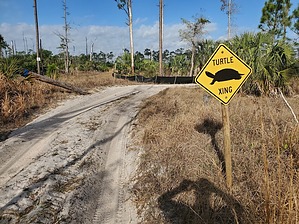
There are a series of trails and roads bordering some private ranch land called the Picayune Everglades Ranch area. Horseback riding and walking are allowed here. Some of the trail is very sandy and similar to walking on a beach. Other parts of the trail are grassy and easier to walk on. You may see some deer in this area, and it may be possible to see bears also.


Hike
From the parking area, hike east on the yellow trail. Within 1/3 mile you will see a blue trail junction and some picnic tables and a junction. Continue going east on the yellow trail. After hiking 0.6 miles, you'll see a private property sign and the road bends slightly to the right, going around the private property. Continue until you have walked a total of 0.9 miles and you will see a junction. There's a yellow trail leading to the south, but I decided to take the yellow trail going north and then east.

Continue until you have traveled a total of 1.5 miles and you will reach a junction. Turn left and you should then be on the blue trail. This blue trail will travel north, northeast, and then northwest. After hiking a total of 2.25 miles from the starting point, this blue trail will turn going west. Keep following this trail west, north, and west again. After hiking a total of 3.8 miles you will reach another junction with a blue trail going west and south. Turn left, going south, and you will follow this blue trail roughly 0.5 miles back to the yellow trail. Once at the yellow trail, turn right and take this trail 1/3 mile back to the starting point.

Check out the Official Route and Triplog.

Leave No Trace and +Add a Triplog after your hike to support this local community.

2023-02-27 Mike_W & HAZ_Hikebot
    WARNING! Hiking and outdoor related sports can be dangerous. Be responsible and prepare for the trip. Study the area you are entering and plan accordingly. Dress for the current and unexpected weather changes. Take plenty of water. Never go alone. Make an itinerary with your plan(s), route(s), destination(s) and expected return time. Give your itinerary to trusted family and/or friends.

     Permit $$
    FL State Parks more info
    2022 Day Entrance Fees range from $4–$10

    Single-Occupant Vehicle or Motorcycle $4.00 - $6.00
    Per Vehicle 2 to 8 people $5.00 - $10.00
    Pedestrian / Passenger Exceeding 8 Per Vehicle $2.00 - $5.00


     Directions
    or
    or
     Road
    Paved - Car Okay

    To hike
    From Ft. Myers area, take I-75 south to Collier Blvd. Take the exit and continue south on Collier Blvd. Continue for 0.2 miles and turn left on Beck Blvd. Continue for 1.4 miles. Continue from the local directions below.

    From downtown Naples, take FL-84 east to Beck Blvd. Pass Collier Blvd and continue for 1.4 more miles. Continue from the local directions below.

    Local directions:
    -----------------
    The road will turn south and the name changes to Benfield Road. Continue for 1 mile and turn left on Newman Road. Continue for 0.3 miles and look for a parking area on the left.
    page created by Mike_W on Feb 27 2023 9:30 am
    helpcorrectionissue

    end of page marker