Route Editor

| Guide | ♦ | 2 Triplogs | 0 Topics |
details | drive | permit | forecast | route |
stats |
photos | triplogs | topics | location |
| 33 | 2 | 0 |
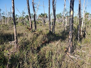
dominant wavelength experience by Mike_W The Collier Seminole State Park Adventure Trail is roughly 17 miles southeast of Naples, FL, and borders the Florida Everglades. This hike is flat, and involves a road and a narrow trail through a nature area, some of which is grassy, and contains palm trees, some pines, and a variety of other sub-tropical plant life. It was evident that there was a fire that burned some parts of this area. It's possible to see alligators in this area but I have not seen them near any trails. It would be more likely to see them in or alongside the main creek or canal which is west of the road traveling north/south. Hike Park at the picnic area which is 0.2 miles southeast of the trailhead and on the south side of the road. At the trailhead, there is mention of driving 0.6 miles to some Ranger station and paying a fee, but since the instructions were inconvenient and there was no mention of what the fee was, we decided to skip doing that. Maybe if there was a way to pay online, and it wasn't so damn inconvenient, we'd pay. I also figured since we didn't park at the trailhead, the fee wasn't really necessary.
After hiking a total of 1.5 miles, look to your right for a narrow trail with some yellow markers. This is the start of the Yellow Trail, according to the map. I didn't see the Yellow Trail, probably because it wasn't marked well, but instead continued north until I traveled a total of 1.66 miles. We'll pick up the Yellow Trail further ahead. There was a gate here and a branch of a road going west and east. Take the east road which appears to follow a fence line for a while. It was a bit grassy here but easy to walk this road. After traveling a total of 1.92 miles, the road turned and went south. After traveling a total of 2.2 miles, the road will head west/southwest. Continue until you have traveled a total of 2.46 miles. Look for the intersection of the Yellow Trail which crosses the road just up ahead. You'll see some yellow coloring on some trees and possibly some ribbons also. I suspect the right branch here leads to the junction that I missed earlier. Turn left onto the Yellow Trail and head south. Once on the Yellow Trail heading south, you'll notice that this trail is narrow, sometimes grassy, but overall should be pretty easy to follow. There will be a few downed trees that you'll need to step over. From where you got onto the Yellow Trail, it's roughly 1.75 miles to get back to the road near the entrance. The trail does some winding. I saw some deer tracks in the wet areas of this trail. If you found the Yellow Trail at the 1.5-mile mark and followed that loop all the way back, your overall hike would have been probably about 0.5 miles shorter. No matter which route you take to get on the Yellow Trail, once you reach the lower junction of the Yellow Trail and the road, turn left and walk south toward the trailhead and Highway 41. Gate Policy: If a gate is closed upon arrival, leave it closed after you go through. If it is open, leave it open. Leaving a closed gate open may put cattle in danger. Closing an open gate may cut them off from water. Please be respectful, leave gates as found. The exception is signage on the gate directing you otherwise. Check out the Official Route and Triplogs. Leave No Trace and +Add a Triplog after your hike to support this local community. | ||||||||||||||||||||||||||||||||||||||||||||||||||||||||||||||||||||||||||||