Route Editor

| Guide | ♦ | 1 Triplog | 0 Topics |
details | drive | no permit | forecast | route |
stats |
photos | triplog | topics | location |
| 4 | 1 | 0 |
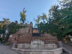
Great In-City Historic Trail by KingLeonidas Logistics/Getting there: Cerro Santa Lucia is located in the heart of Santiago, so it's easy to get to by public transportation or taxi. The closest metro station is Santa Lucia, which is just a few blocks away. If you're driving, there are several paid parking lots nearby. When we were there the park was only open during the day with security clearing the park before sunset (not sure if this is normal or if it was due to the recent unrest and vandalism).
The main entrance to Cerro Santa Lucia is located on the corner of Avenida Libertador Bernardo O'Higgins and Calle Merced. Look for the iconic white archway and the statue of Pedro de Valdivia. There is no fee to enter the park. Navigation: The trail is well-marked and easy to follow. There are several paths to choose from, but they all lead to the top of the hill. The main trail is paved, with some stairs and inclines. There are also several lookout points and gardens along the way. Weather: Santiago has a Mediterranean climate, with hot, dry summers and cool, wet winters. The best time to hike Cerro Santa Lucia is in the spring or fall, when temperatures are mild and the skies are clear. As this was a layover for our Patagonia trip, we were there in the early Summer so the weather was very much like Phoenix in May. Be sure to bring plenty of water, sunscreen, and a hat as the sun and radiated heat of stonework can be intense. Trail Conditions: The trail is generally in good condition, with some uneven pavement and odd aspect ratio stairs. The trail can be crowded on weekends and holidays. History Cerro Santa Lucia has a rich history that dates back to the colonial era. The hill was once used as a natural lookout by the indigenous Mapuche people, who would light fires to communicate with nearby tribes. In the 16th century, the Spanish conquistador Pedro de Valdivia founded the city of Santiago on the plains below the hill. Cerro Santa Lucia was also an important fortification during the colonial era. In the early 17th century, the Spanish built a fortress on the hill to protect the city from attacks by indigenous people and pirates. The fortress was later expanded and became known as Fort Hidalgo, named after the Spanish governor of Chile at the time. The fort was decommissioned in the mid-19th century and fell into disrepair, but some remnants of the original fortification can still be seen along the trail. In the late 19th century, during the presidency of Benjamin Vicuña Mackenna, the hill was transformed into a public park and was extensively remodeled to resemble a medieval castle. The park's design was heavily influenced by the romanticism movement, which idealized the beauty of nature and the past. The park features several fountains, sculptures, and terraces, and offers panoramic views of the city. General Comments and Musings: In addition to the panoramic views from the top, the hill is a good place to take a break from exploring the city and cool off in the shade. There are several gardens and fountain areas which are a nice spot to relax if you are visiting the city in the summer. Check out the Official Route and Triplog. Leave No Trace and +Add a Triplog after your hike to support this local community. | ||||||||||||||||||||||||||||||||||||||||||||||||||||||||||||||||||||||||||||||||||||||||