Route Editor

| Guide | ♦ | 1 Triplog | 0 Topics |
details | drive | permit | forecast | route |
stats |
photos | triplog | topics | location |
| 13 | 1 | 0 |
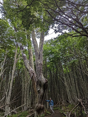
Pleasant Day Hike outside Punta Arenas by KingLeonidas Logistics/Getting there: Magallanes National Reserve is located on the outskirts of Punta Arenas. The reserve is accessible by car, taxi, or bus and there is ample parking at the entrance. We originally planned to take the bus but after looking at the erratic and seasonal schedule and hearing how inexpensive the taxis were, we opted for the taxi route. There is no public transportation at the park so we arranged for the taxi driver to return to the park to pick us up at a prearranged time for the return trip, which worked fine.
The Circuito Las Lengas trailhead is located at the entrance to the reserve. There is a sign marking the start of the trail, and a map of the reserve is available at the ranger station. The fee to enter the park was 4000 CLP per person (~$5 USD 2023). Navigation: The Circuito Las Lengas trail is a well-marked loop. The trail is well-maintained and easy to follow, with several signs indicating the direction of the loop. Weather: The weather in Punta Arenas can be unpredictable, with strong winds and rain at any time of year. It is recommended that you dress in layers and bring rain gear, especially during the winter months. While we were there there was continuous mist and drizzle as well as a cold wind. Rain gear was absolutely necessary, we would have been soggy and cold without it. The mist did inhibit the visibility from the numerous miradors along the trail, a clear day would have provided a better experience. Trail Conditions: The trail is in good condition, with some rocky sections and frequent muddy patches. There are several boardwalks and bridges over wetlands and streams. The trail was slippery in some areas, but we managed not to fall despite the mud. The park was not very popular and we basically had the place to ourselves, the sub-optimal weather and that it was a weekday may have contributed to the lack of people. We did the loop in a clockwise direction which makes the 1st 1/4 of the hike a fairly steep uphill climb to Mirador Zapador Austral. The remainder of the route is level or downhill from there. General Comments and Musings: The trail takes you through ancient forests of lenga trees, wetlands, and past views of the Andes Mountains and nearby Punta Arenas. The reserve is also home to a variety of wildlife, including guanacos, foxes, and condors (although none made an appearance while we were there). The trail is worth doing if you are in the area and have some free time but pales in comparison to the stunning scenery of Torres del Paine National Park. Check out the Official Route and Triplog. Leave No Trace and +Add a Triplog after your hike to support this local community. | ||||||||||||||||||||||||||||||||||||||||||||||||||||||||||||||||||||||||||||||