username
X
password
register
for free!
help
  

Stanfield Hill 2308 Loop, AZ

Guide 1 Triplog  0 Topics
  3 of 5 
Fav
Wish
0
details
drive
permit
forecast
route  
stats
photos
triplog
topics
location
20 1 0
Statistics
tap icons for details
Distance One Way 5.19 miles
Trailhead Elevation 1,731 feet
Elevation Gain 214 feet
Accumulated Gain 316 feet
Kokopelli Seeds 6.24
feature photo
Photos Viewed All MineFollowing
Inaugural Calculation on Button Tap!
20  2023-03-21 kingsnake
Author
author avatar Guides 107
Routes 281
Photos 10,172
Trips 800 map ( 7,317 miles )
Age 61 Male Gender
Location Sunnyslope, PHX
Historical Weather
Trailhead Forecast
Radar Map
Expand Map
Preferred Dec, Jan, Feb, Nov → 7 AM
Sun  5:21am - 7:31pm
Official Route
 
0 Alternative
 
 Water


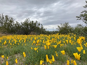
There is a dearth of established hiking routes in the Casa Grande area. Granted, this is 20 miles west of Casa Grande, and even 10 miles west of Stanfield, but everything in between is flat and agricultural, so this is what I put together.


Basically, it is a loop around a series of small hills between Vekol Valley and Stanfield, near the "peak" of the shallow pass on I-8. (At which all the services appear abandoned.) Hill 2308 is the most prominent.

The loop is short, and all on dirt roads or sandy wash bottoms. There are lots of horse tracks from the nearby mini-ranches on Robin Rd., and a fair number of OHV tracks as well. (Many crisscross the area, so you can shorten or extend this loop.) The sandy wash bottoms never get tiring.


If you want some extra AEG, Hill 2031 (230 AEG), Hill 2272 (360 AEG), and even Hill 2308 itself (560 AEG) are attainable with minimal difficulty.

The hike is not worth the $15 State Trust annual fee, but if you have the permit, and are in the area anyway, the scenic formations and, in season, great flowers are worth your while.

Check out the Official Route and Triplog.

Leave No Trace and +Add a Triplog after your hike to support this local community.

2023-03-22 kingsnake

    One-Way Notice
    This hike is listed as One-Way.

    When hiking several trails on a single "hike", log it with a generic name that describes the hike. Then link the trails traveled, check out the example.
    WARNING! Hiking and outdoor related sports can be dangerous. Be responsible and prepare for the trip. Study the area you are entering and plan accordingly. Dress for the current and unexpected weather changes. Take plenty of water. Never go alone. Make an itinerary with your plan(s), route(s), destination(s) and expected return time. Give your itinerary to trusted family and/or friends.

     Permit $$
    AZ State Recreational Land Permits
    For hiking, driving & sightseeing purposes, you seek a recreational permit.
    Under "Recreational Land Use" in the link above.
    2022 - $15.00 individual
    2022 - $20.00 family limited to two adults and children under the age of 18
    Plus $1 processing fee
    The permitting process is quick, you will be emailed your permit instantly.

    Land Parcel Map


     Directions
    or
    or
     Road
    FR / Jeep Road - Car possible when dry

    To hike
    From I-10, take exit 199 west onto I-8. In 26 miles, take exit 151 north, back and to your right, onto AZ-84. In ¾ mile, turn left onto Ralston Rd. In ⅓ mile, at the small hill before the powerline, turn left onto the dirt road/pullout.
    page created by kingsnake on Mar 22 2023 9:33 am
     90+° 8am - 6pm kills
    helpcorrectionissue

    end of page marker