Route Editor

| Guide | ♦ | 74 Triplogs | 0 Topics |
details | drive | no permit | forecast | route |
stats |
photos | triplogs | topics | location |
| 167 | 74 | 0 |
embracing social circles by LindaAnn  Overview: Short, but steep, loop hike which passes several old mines in the preserve. Newly designated as of March 2023, the aptly named loop is comprised of popular social trails that have now become official. Overview: Short, but steep, loop hike which passes several old mines in the preserve. Newly designated as of March 2023, the aptly named loop is comprised of popular social trails that have now become official.Getting there: The true start of Prospector Loop starts about 1 mile from the Bursera Trailhead. Plan accordingly for the 2 extra miles just getting to/from the loop. From the trailhead, head north on the main trail, which is Bursera Trail. Take Bursera approx 0.40 miles to a large fork, which is signed. Stay right to turn onto what is now signed as Lost Ranch Trail. Follow the signs for Lost Ranch another 0.55 miles as you drop into a large wash. Immediately upon reaching the wash, there is a signed junction for three trails.
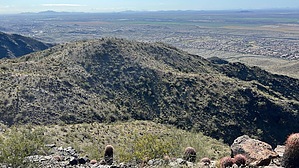
As the trail starts its turn to the northeast, it suddenly becomes rather steep as you make your way up the west and northwest side of the mountain. There are no switchbacks, just up, although an early morning start will give you some shade. Looking to your left, you can see the descending half of the loop across from you. Continuing up, the trail curves north, generally taking the shortest route possible. You will pass a few small mine prospects along the way, before slightly leveling off near the top of the loop. There will be another Y junction at the north end of the loop. Stay left to continue on the loop. Turning right will take you uphill a short distance to the junction with National Trail. Staying left, the trail turns to the southwest and downhill. It's a steep descent, but several switchbacks make it slightly less steep than the eastern half of this loop. As you descend, you'll pass several larger mines, with the trail crossing several tailings piles. Lost Ranch becomes visible below you to the right. The western half of this loop has an abundance of Bursera trees, which have a pleasant fragrance when leafed out. Nearing the bottom of the descent, you will pass the largest mine along the loop. One adit is just off the side of the trail, and the other is shortly below that entrance, about 150' off the trail. The tunnels go back a few hundred feet, although entering the mines is strongly discouraged and the collapsing ceilings will give you pause. These days, the mines house a colony of bats, and sitting outside the entrances on spring evenings just after sunset can give a fun show of the bats leaving for the evening. Rattlesnakes seem to enjoy the cooler air of the mines during the summer. Once past the large mine, the trail continues downhill into a large wash, crosses it, and connects with Lost Ranch Trail on the other side. You'll take an old Jeep road south and back into the wash, staying the wash for a short distance before completing the loop at the original junction. While this is a short loop, it has some of the more challenging terrain of the trails in the preserve. Use caution on the narrow sections, and there is a fair amount of loose rock in many places.
Check out the Official Route and Triplogs. Leave No Trace and +Add a Triplog after your hike to support this local community. | |||||||||||||||||||||||||||||||||||||||||||||||||||||||||||||||||||||||||||||||||||||||||||||||||||||||||||||||||||||||||||||||||||||||||||||||||||||||||||||||||||||||||||||||||||