 Route Editor

| Guide | ♦ | 13 Triplogs | 0 Topics |
details | drive | permit | forecast | route |
stats |
photos | triplogs | topics | location |
| 131 | 13 | 0 |
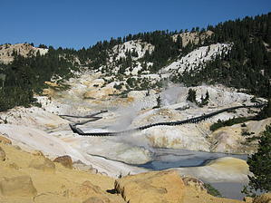
Pathway To The Darkside by AZLOT69 All four types of volcanos can be located within Lassen National Park. These are plug dome, shield, cinder cone and strato. There is one furnace that generates all the features within the park which include steam vents, mud pots and boiling springs. Bumpass Hell is the largest escape valve for this active but resting volcanic area. History Discovered in 1864, Mr. Kendall Vanhook Bumpass filed a mining claim and intended to develop the area into a tourist attraction. One day while walking in the area Bumpass fell thru the thin crust of earth into a mud pot severely burning his leg and eventually loosing it. His dream never materialized.
The hike is three miles out and back gaining about five hundred feet early, then loosing 250 feet descending into Bumpass Basin. The sixteen acre basin features seventy five fumaroles, hot springs, and mud pots in the shadow of Bumpass Mountain, a dome volcano. What sounds like a jet engine is the Big Boiler, the hottest fumarole in a non erupting volcano in the world. The steam coming out of this fumarole is measured at 322 degrees Fahrenheit. Hydrogen sulfide gas released from the earth gives the area a rotten egg smell. Hike The hike starts off very rough and begins its climb of five hundred feet to some nice panoramic views of Lake Helen, Brokeoff Mountain, Lassen Peak, and Diamond Peak. The trail smoothes out going through some forested areas with vast views of valleys to the south and east. Most of the summer water can be heard in the creeks below as area melting snow pack lasts well into August. After a short time along a ridgeline, the trail starts down the other side to a viewpoint of Bumpass Basin. The trail descends steeply from here into the basin. At the bottom of the descent flows a creek away from the geothermal features. The creek bed is lined with colorful minerals. The danger associated with the thin crust of the basin is managed by a series of boardwalks to prevent injury. Think of the area as under construction. The area is constantly changing and there is potential for danger if you leave the boardwalk. After taking in the many viewpoints return the way you came or you can continue on connecting trails. Check out the Official Route and Triplogs. Leave No Trace and +Add a Triplog after your hike to support this local community. One-Way Notice This hike is listed as One-Way. When hiking several trails on a single "hike", log it with a generic name that describes the hike. Then link the trails traveled, check out the example. | ||||||||||||||||||||||||||||||||||||||||||||||||||||||||||||||||||||||||||||||||||||||||||||||||


