Route Editor

| Guide | ♦ | 1 Triplog | 0 Topics |
details | drive | no permit | forecast | route |
stats |
photos | triplog | topics | location |
| 51 | 1 | 0 |
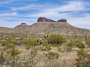
the drive is half the challenge! by Mike_W  Overview OverviewCoffeepot Mountain is in a very remote area about 16 miles east of the small town of Aho, AZ. It is named this because it appears to look like a coffeepot, or teapot, from a distance, but you'll have to use your imagination. The drive is probably half the challenge - almost 16 miles down a 4x4 road which starts fine, but then gets worse the further out you get. The hike itself is under 4 miles of "open country". There are some steep areas, but nothing that would require rock climbing or ropes. Prologue I had a trip planned to Rocky Point, and I thought it was a good time to visit Coffeepot Mountain since it wasn't far off the route from my drive down there. I tried to drive out there last July (it would have been quite hot) but didn't get very far because of some deep puddles, perhaps small ponds, in the road in just the first mile. I suppose that was for the best since July is not the greatest time of year to be in this area. I didn't know why it was called Coffeepot Mountain but I noticed when driving closer to it that it looked a bit like a teapot, rather than a coffeepot. Either way, it was a unique and interesting name.
From the starting point you will need to cross 2 or 3 washes before you start climbing up the ridge. Climb to the nearest saddle which should be northwest of where you started. Once you are on the ridge keep going up staying in the middle of the ridge. At times you may see animal trails, but this ridge is pretty easy to follow up. This is an open country hike, there are some dense areas of teddy bear cholla in some places but you will be able to walk around the dense sections. Just watch the ground for stray chollas. Pretty soon, you will see a steep rocky "thimble" in front of you. The thimble can be thought of as the handle to the coffeepot. When I was first here, I wasn't aware if climbing this was necessary because there were no routes or trip reports for this great hike! The good news is it's not necessary to climb this thimble to summit this peak. Hike up to the thimble and when you get close you will see it's very vertical here. By the way, a few minutes below the thimble, I saw some dug-out areas that would make great shelters. You can walk around the east side of the thimble. There is somewhat of a trail here and it looked like people and/or animals have been through here before. After going around this thimble you will get your first look at the peak since you saw it from the drive in. From here, it's only another 1/4 to the top. Just follow the ridgeline up and you will eventually make it to the peak. At the peak, you will see a registry under a rock pile. There's also a nice organ pipe cactus at the top. You can walk north for a few minutes and be able to look down and see the "spout" of the coffeepot and look south to see the "thimble" or part of the coffeepot handle. All in all, it was a great hike. But, the drive to get out there was half the challenge. Check out the Official Route and Triplog. Leave No Trace and +Add a Triplog after your hike to support this local community. | ||||||||||||||||||||||||||||||||||||||||||||||||||||||||||||||||||||||||||||||||||||||||