 Route Editor

| Guide | ♦ | 2 Triplogs | 0 Topics |
details | drive | permit | forecast | route |
stats |
photos | triplogs | topics | location |
| 17 | 2 | 0 |
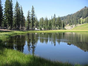
No Hardboiled Eggs Here by AZLOT69 Lassen Volcanic National Park is a land of extremes. From the hottest fumarole in the world to the snowiest place in California. A land of fire and ice which on this trail as described starts from Bumpass Hell crosses one of fourteen permanent snowfields in Lassen through areas that get as much as forty feet of snow yearly. The destination being Cold Boiling Lake, a quaint tarn that does not appear at first glance to be volcanic. Upon closer examination at the southeast corner of the lake it appears to be boiling. These are gasses bubbling to the surface from the furnace deep below. The water is ice cold. Hike Few people continue past Bumpass Hell. This trip starts from the small footbridge over the creek at Bumpass Hell and climbs the ridge to a nice vantage back at the geothermal area. The trail follows the ridgeline and is fairly difficult to follow at times due to the limited hiking season and alpine environment which is light on vegetation. This area normally has snow pack into August. Following the natural terrain around the south side of the mountain there is tree cover from old growth forest making for a pleasant section of trail shaded from the summer sun. The descent starts fairly quickly as Cold Boiling Lake lies about seven hundred fifty feet below. The trail is very narrow and hugs the mountain far above mineral meadow. Dacite cliffs line the north side of the trail. There are several small flower bordered streams crossed which flow from above snow melt. Mt Conard can be observed in the distance and East Sulphur Creek can be seen and heard below. Soon Crumbaugh Lake can be seen below. Beyond Crumbaugh try to spot Reading Peak and Lake Almanor. Other points of interest are Saddle Mountain and to the right of that lies Mt Harkness. The trail continues along a shelf then dives into old growth forest made up of pine and fir which has been twisted and contorted by the annual snowfall. There is much deadfall in this area but the trail is clear. Soon Cold Boiling Lake comes into view. The quiet valley often offers some nice opportunities for wildlife observation and photography. The southeast side of the lake is the easiest access to see the bubbling water. From here the trail climbs a short hill then swings north, leveling off for a pleasant mixed meadow and forest hike to the Kings Creek Picnic area, which is an alternative trailhead for this hike. A shuttle prearrangement is a great idea or you can return the way you came. Check out the Official Route and Triplogs. Leave No Trace and +Add a Triplog after your hike to support this local community. One-Way Notice This hike is listed as One-Way. When hiking several trails on a single "hike", log it with a generic name that describes the hike. Then link the trails traveled, check out the example. | |||||||||||||||||||||||||||||||||||||||||||||||||||||||||||||||||||||||||||||||||||||||||||||||||||


