Cerro La Choya - Lazy Hill, SO

Guide 2 Triplogs Mine 0 0 Topics
 
4 of 5 
Fav
Wish
0
details
drive
no permit
forecast
route  
stats
photos
triplogs
topics
location
45 2 0
Statistics
tap icons for details
Difficulty 2.5 of 5
Route Finding 3 of 5
Distance Lasso-Loop 1.6 miles
Trailhead Elevation 55 feet
Elevation Gain 304 feet
Accumulated Gain 429 feet
Avg Time Round Trip 1.5 hours
Kokopelli Seeds 3.75
 Interest Off-Trail Hiking & Peak
 Backpack Possible - Not Popular
unreported if dogs are allowed
editedit > ops > dogs to adjust
feature photo
Photos Viewed All MineFollowing
Inaugural Calculation on Button Tap!
23  2023-05-08 Mike_W
22  2023-04-10 Mike_W
Author
author avatar Guides 57
Routes 87
Photos 3,471
Trips 236 map ( 1,336 miles )
Age 51 Male Gender
Location Tucson, AZ
Historical Weather
Trailhead Forecast
Radar Map
Expand Map
Preferred Nov, Dec, Jan, Feb → 3 PM
Seasons   Autumn to Spring
Sun  5:41am - 7:21pm
Official Route
 
1 Alternative
 
 Water
Nearby Area Water
[ View More! ]
no photo labels yet
+Add > Photos to this Guide
then label as applicable
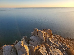
it's only "lazy" to take an ATV up!
by Mike_W

Overview
This is a 300+ foot hill bordering the ocean that is located 6 miles west of Rocky Point and about 2 miles east of the small town of La Choya. This is a tourist area and you will often see quads, dune buggies, and sometimes 4x4 trucks riding up the sandy dunes on the northeast side of this mountain. There are some trails on the south and east sides of this hill, but there are many ways to hike to the top of this hill. Other known names of this hill are San Juan Hill and Competition Hill.Hike
I started off by walking through the sand and going west from where I parked. Within about a minute the sand started getting deep and on the steeper sections, I was sliding back at least half of the distance of my stride. After several minutes of struggling through the sand, I thought it might be easier to get on the rocky ridgeline and climb UP from there. It started off well, but then got very steep very fast. After several minutes of climbing, I realized there were a lot of ups and downs on this route. When looking to the southeast, I could see that the sand dunes were already quite far below me. I was already committed to the ridgeline. I just took my time on the steep parts and then when I got higher up I ran into what looked like a trail.

The trail seemed to go back down into the sandy area which was not what I wanted, so I got back on the ridgeline heading up and I was only a few hundred feet from the high point. In this area, I saw some metal stairs leading up to a section of the zipline. I continued higher up and perhaps at the highest point, I saw a broken metal cross. Then, at a slightly lower point, I saw a small structure about the size of a dog house with a cross inside. I took some photos from the high point of the ocean and the surrounding area.

At this point, the sun was setting and I needed to plan my route down. The ATVs and quads were down at the bottom and on their way out. This was a good time to cross the sand dunes to the northern side and continue down from there to where I was parked. I got down in 20 minutes, faster than I expected. I learned that descending through sand dunes is very fast, easy, and fun!

Note
If you need a comfortable place to stay in this area, I have a one-bedroom oceanfront condo at the Sonoran Sea Resort that I rent out. You can find more information on the website which is in my profile, or just send me a private message.

Check out the Official Route and Triplogs.

Leave No Trace and +Add a Triplog after your hike to support this local community.

2023-04-11 Mike_W
    WARNING! Hiking and outdoor related sports can be dangerous. Be responsible and prepare for the trip. Study the area you are entering and plan accordingly. Dress for the current and unexpected weather changes. Take plenty of water. Never go alone. Make an itinerary with your plan(s), route(s), destination(s) and expected return time. Give your itinerary to trusted family and/or friends.

     Permit $$
    None


     Directions
    or
    or
     Road
    Paved - Car Okay

    To hike
    From the Sandy Beach area of Puerto Penasco, continue west towards "Wrecked on the Reef". Pass the entrance for that and continue west toward Rocky Point Ziplines. There's a zipline on this hill and if you'd like to try it, look for the billboard and call the number listed.

    The price started at $25 when I saw the billboard in April 2023. About 800 feet past the zipline entrance you should see a wide dirt road heading toward the hill. Turn here and take this road in the direction of the hill. You may see some quads, dune buggies, and cars riding up the hill. The sand gets a bit deep in the middle so you'll need a 4-wheel drive to get on the higher section of the road. But, the good news is you only need to drive up as far as you want. You can start your hike anywhere. I had a 4-wheel drive truck, so I drove up to where there was a fence and turned going to the right of the fence. I continued for about another 300 feet and parked off to the side. Here's where I started my hike.
    page created by Mike_W on Apr 11 2023 5:42 pm
     90+° 8am - 6pm kills
    Avoid Heat Illness - stay cool
    helpcorrectionissue

    end of page marker