Route Editor

| Guide | ♦ | 1 Triplog | 0 Topics |
details | drive | no permit | forecast | route |
stats |
photos | triplog | topics | location |
| 22 | 1 | 0 |
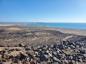
What the surface of the dark side of the moon might look like by Mike_W Cerro Prieto is a hill of dark lava rock, just under 500 feet high, about a 20-minute drive from the Sandy Beach area of Rocky Point, and about 1 mile southeast of Laguna Shores Resort. Some construction roads are going up this hill on the northeast side, but these roads don't go to the top. However, it is fairly easy to walk the ridgeline to the summit. From the summit, you'll be only 1 km from the ocean and there are some nice views all around. Prologue Cerro Prieto is Spanish for Dark Hill. I hiked another peak in Arizona with the same name a few months ago. Both places had a lot of lava rock. This particular hill is unique because it is very close to the ocean with nice views all around.
My original plan was to hike Cerro La Choya and I knew it was a short one. While looking at the map I discovered this hill which was only about a 20-minute drive up the road, so I decided to combine this hill with Cerro La Choya and do both on the same day. I started off this hike heading toward a construction road going up the hill. This road was rather rocky in some parts but it was easy to follow. After following this road for 0.4 miles, the road turned right and didn't seem to go to the summit. Instead, I turned left at this point and then started my rock scramble. The terrain was not steep and easy to walk up. The rocks were stable for the most part. Within a few minutes, I reached the top. There wasn't much brush at all. During the entire hike, I think I saw a few ocotillo plants, one cactus, and a lot of dead-looking small plants. There was a radio tower near the top and great views of the ocean. I could see Laguna Shores Resort to the northwest. After exploring the peak and walking down to where the radio towers were, I decided to do another rock scramble going north and down to the road which appeared to continue east back to where I first left the road. The road scramble ended up being about 500 feet. Then, once I hit the road, I followed it east for about 0.2 miles and it connected back to the area where I first turned off the road. I continued down the road the same way I came up to get back to my starting point. Note If you need a comfortable place to stay in this area, I have a one-bedroom oceanfront condo at the Sonoran Sea Resort that I rent out. You can find more information on the website which is in my profile, or just send me a private message. Check out the Official Route and Triplog. Leave No Trace and +Add a Triplog after your hike to support this local community. | ||||||||||||||||||||||||||||||||||||||||||||||||||||||||||||||||||||||||||||||||||||||||