 Route Editor

| Guide | ♦ | 2 Triplogs | 0 Topics |
details | drive | permit | forecast | route |
stats |
photos | triplogs | topics | location |
| 39 | 2 | 0 |
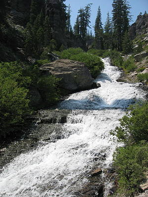
A Waterpark In The Wilderness by AZLOT69 Kings Creek originates at the highest point in Lassen Volcanic National Park. Lassen Peak stands at 10,457 feet. The tremendous snowfall and permanent snowfields supplemented by several springs create a year round creek flow that many times resembles a river. By the time the creek reaches the Kings Creek trailhead at 7284 elevation it has built up quite a head of steam. The trail starts at this point and you can feel the energy of the creek from beginning. The creek has leveled off as it crosses underneath highway 89 and is crossing upper meadows but its momentum creates a roar as it builds towards the awaiting descent of an additional 1286 feet. The trail will follow, precipitously close at times offering an exhilarating experience.
Hike The trail starts with a walk thru upper meadows. An early start will almost certainly guarantee some wildlife sightings. Kings Creek can be seen off to the right flowing swiftly towards and then paralleling the trail eastward. Proceed straight at a marked trail junction four tenths of a mile in. In a few hundred yards there is another choice. The trail to the right is preferred by the author. It is a steep and rough scramble down what some may call rock steps that will require many to use hands to maintain balance. Caution is needed due to loose scree and the loud, beautiful distraction of Kings Creek immediately off to your right. There are about a dozen falls with the creek cascading between them. Ample photo opportunities are enjoyed along the way. The trail option to the left is for equestrians. It swings far away from the creek with no views or sound. It is equally steep in sections, without the rock steps but with treacherous loose scree. The two trails rejoin at the bottom of the creek cascades. The trail and creek moderate at this point as another trail junction appears. Again go straight as Kings Creek Falls lie ahead. In a few hundred yards there is a guard rail. It is a seventy foot drop from here as the creek takes a big plunge. Some will go ahead and scramble down the rocky, loose embankment to get to the base of the falls and enjoy the chilly water and mist but there is no official trail. Few take the trail further. The trail continues northeast away from the creek and climbs over two ridges where it plunges itself in a steep decline. The old forest growth seems haunting. Bubbling creeks from several springs can be heard and are flowing as tributaries preparing to join Kings Creek. There are a few wet crossings where wild flowers are abundant and an open meadow with deep grasses. About two miles past Kings Creek Falls the trail rejoins Kings Creek where it meets Summit Creek. Kings Creek can be a challenge to cross at this point with the trail continuing along the south bank a short distance where it meets the Pacific Crest Trail. There are a couple nice backpack camping spots in this area. From this point you can continue on or retrace your steps. Check out the Official Route and Triplogs. Leave No Trace and +Add a Triplog after your hike to support this local community. One-Way Notice This hike is listed as One-Way. When hiking several trails on a single "hike", log it with a generic name that describes the hike. Then link the trails traveled, check out the example. | ||||||||||||||||||||||||||||||||||||||||||||||||||||||||||||||||||||||||||||||||||||||||


