Route Editor

| Guide | ♦ | 2 Triplogs | 0 Topics |
details | drive | permit | forecast | route |
stats |
photos | triplogs | topics | location |
| 49 | 2 | 0 |
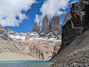
The Crown Jewel of Torres del Paine National Park by KingLeonidas Torres del Paine National Park is located in southern Chile, about 150 kilometers north of Puerto Natales which is where we started our day. Several bus companies offer transportation to the park from Puerto Natales. You must get your bus tickets for the round trip in advance, you cannot (at the time of writing) buy return tickets once inside the park. You will need the early morning departure to have enough time to complete the hike. For the return trip, if you are very fast, it is technically possible to get the 2nd to last return bus back to Puerto Natales. The safer bet is to book on the last departure so you don't get stuck if things take longer than you expect. For bus companies, I recommend any but Turismo Zaahj (you can read my triplog for the full details on that). From the buses, once in the park, you will transfer to shuttles (which charge a small additional fee) that take you from the main road to the trailhead. You will need to present a permit to hike Torres del Paine at this point which has to be purchased online in advance and either downloaded to a cell phone or printed (there is no cell reception in the park). You do need to have the permit in some form with you to get in (this caused a lot of trouble for people who didn't know this and showed up without a permit). The shuttle will drop you off at the hotels/lodges near the trailhead, the hike starts from here. If you have a car you can drive to the trailhead, there seemed to be a good amount of parking available there although you will still need to present the relevant permits at the guard station where the bus riders transfer to shuttles.
The park entrance permit costs $32 (21,000 CLP) during the high season, The permit for the Torres del Pain trail costs an additional $9 (7,300 CPL), the shuttle is ~$3.50 (3,000 CLP), and round trip bus from Puerto Natales varies but is around $30. Navigation: The hike to Mirador Torres del Paine is a challenging trek that takes about 8-10 hours to complete round-trip. The trail is well-marked and easy to follow, but there are some steep sections and rocky terrain that where the path is less obvious. There are generally enough people hiking the trail that the route is generally apparent. Refugio Chileno is along the way and provides an approximate halfway mark for the hike. Time Limits and Ranger Closures: It is important to note that there are time limits for hiking to Mirador Torres del Paine. The last entry to the trail is at 3 pm, and the trail must be completed by 8 pm. This is to ensure that all hikers have enough time to complete the trek and return to the trailhead before dark. There are signs as you progress upwards indicating the latest hour that you may pass and the hour you must return by. These start after the Refugio (which I think is available to trekkers at all hours). The last portion of the ascent is also monitored/patrolled by rangers who, from what I heard, are quite strict about enforcing the rules. After a certain hour, rangers close the end of the trail to ensure that everyone gets back down before dark. Weather: The weather in Torres del Paine National Park can be unpredictable, with strong winds, rain, and snow at any time of year. It is recommended that you dress in layers and bring rain gear and warm clothing, especially during the winter months. The 1st and last portions of the hike are exposed and subject to the sun near the bottom (which can be baking) and high winds at the top (which can be freezing coming off the ice and water). While we were there it was both; I started (and indeed finished) the hike up in shorts but after reaching the mirador quickly put my pant legs and jacket back on. Once we had descended below the treeline on the way back, I reverted to shorts again. Trail Conditions: The trail to Mirador Torres del Paine is in good condition, with some steep sections and rocky terrain. The steepest portions of the trail are at the very beginning and the summit. There were also several muddy sections where trekking poles would have been useful but were not strictly necessary. The trail passes through several ecosystems, including forests, meadows, and glacial valleys, and offers stunning views of the Paine Massif. Refugio Chileno is at the halfway point for the trail. The refugio offers overnight accommodations for those who want to break up the hike into two days. This and other refugios are stopping-off points for backpackers doing the W or larger O trek. They will camp here and leave the heavier gear behind while making the ascent to Torres del Paine. The refugio also offers refreshments (although steeply-priced) and bathrooms that day hikers and trekkers alike can make use of. General Comments and Musings: There is a reason that this hike is the namesake of the park; it is unparalleled. We saved this route for the very end of our trip and as a result ended up (somewhat by accident) seeing the best the park has to offer in order of increasing impressiveness. This was great because it made every hike seem even better than the one before (and they were all spectacular). We also lucked out on the weather. When we arrived in Puerto Natales, we ran into tons of trekkers in the hostel that had just come down from Torres del Paine and other trails that had heavy cloud cover and nonstop rain. So their hiking and camping conditions were miserable and they could not see or photograph any of the famous views. The weather was breaking just as we arrived and we had views of the Torres passing in between small cloud formations with some snow still on the summits. It was stunning. This is also a challenging hike from both the distance and elevation perspectives, it is not terribly technically challenging but your endurance will be tested. That said, it is not significantly more challenging than some of the other famous hikes in the park (the French Valley we did the day prior is similar in stats) so this trail is by no means the exclusive domain of athletes. This was a phenomenal trip and a great way to finish our adventure in Torres del Paine. Check out the Official Route and Triplogs. Note This is a moderately difficult hike. Leave No Trace and +Add a Triplog after your hike to support this local community. | |||||||||||||||||||||||||||||||||||||||||||||||||||||||||||||||||||||||||||||||||