 Route Editor

| Guide | ♦ | 1 Triplog | 0 Topics |
details | drive | no permit | forecast | route |
stats |
photos | triplog | topics | location |
| 18 | 1 | 0 |
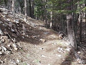
Kayser Rolls by DixieFlyer Kayser Mill Trail #80 is in the Manzano Mountains and the Cibola National Forest and is about 75 miles south of Albuquerque. The Kayser Mill Trail begins on FR 422 and climbs to the Manzano Crest Trail. Beginning a hike on the Kayser Mill Trail is the shortest way to hike to Manzano Peak, the highpoint of the Manzano Mountain range. Hike The trail begins at a turnoff on FR 422, where a sign marks the start of the trail. The GPS coordinates are: 34.58707, -106.421186. The trail is on an old forest road for 3/4 mile. After 0.45 miles you'll come to a trail junction with the Cottonwood Trail #79, which goes to the left. Continue for another 0.3 miles and the road ends. To your left is a sign welcoming you to the Manzano Mountain Wilderness, even though the wilderness boundary is another 0.4 miles away. Next to the signage, the trail continues as a single-track trail.
Just continue following the trail. Some sections of the trail are in open areas without trees, but other sections have a nice tree canopy. As you gain elevation, more of the hike has tree cover. Lower sections of the trail are in pinon pine, juniper, and Gambel oak woodlands, but there are ponderosa pines as you gain elevation. After 2.5 miles you'll cross a talus field. The trail is quite distinct through the talus field, which is about 200 feet or so across. After 3.3 miles the trail will end at a grassy saddle where it meets the Manzano Crest Trail, which is part of Grand Enchantment Trail (GET) #35. At this point, you can either return to the trailhead; take a right turn going north on the Manzano Crest Trail toward Gallo Peak; or take a left going south on the Manzano Crest Trail to Manzano Peak. Note At times this trail can be overgrown and have some deadfall on it, although when the author of the guide did the hike the trail was in good condition and was easy to follow and navigate. There were 5-6 dead trees across the trail, but they were easy to go over or around. There was some vegetation alongside the trail, including the dreaded New Mexico Locust, although, for the most part, it was not encroaching on the trail. However, without occasional maintenance, it is possible that the trail could be overgrown in the future. If you are unsure about trail conditions, it might be worthwhile to contact the Mountainair Ranger District of the Cibola National Forest. Their phone number is 505-847-2990. Check out the Official Route and Triplog. Leave No Trace and +Add a Triplog after your hike to support this local community. One-Way Notice This hike is listed as One-Way. When hiking several trails on a single "hike", log it with a generic name that describes the hike. Then link the trails traveled, check out the example. | ||||||||||||||||||||||||||||||||||||||||||||||||||||||||||||||||||||||||||||||||||||||||||||||||


