Route Editor

| Guide | ♦ | 4 Triplogs | 0 Topics |
details | drive | permit | forecast | route |
stats |
photos | triplogs | topics | location |
| 85 | 4 | 0 |
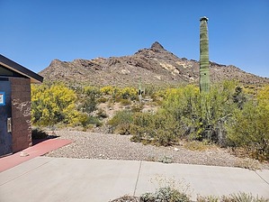
a memorable and enjoyable hike in the OPNM! by Mike_W  Overview OverviewPinkley Peak, at a height of 3,145 feet, is a challenging off-trail hike in the Puerto Blanco mountain range which is inside the Organ Pipe National Monument area about 5 miles North of the Arizona/Sonora border along AZ-85. This hike is somewhat technical and does involve some scrambling across some rocky areas which can be steep at times. You'll want to use a good GPS and know the route ahead of time for safety reasons. Along this hike, you'll see some of the endangered organ pipe cactus, many rock overhang areas which provide great shelter, and at least one major natural arch or window which appeared to be large enough to walk through. Hike Start by hiking West/Northwest toward the highest point that you can see. The first 0.5 mile of this hike is an open country hike through some rolling hills. You'll cross a few washes and there won't be a lot of obstacles. After hiking a total of 0.7 miles, the brush will get thicker and you will see a canyon to your right. I believe the easiest route at this point is to cross the canyon and stay on the rocky area, away from the brush and cactus. At this point, you will not be heading directly at the high point but you will want to choose a line that is roughly 10 degrees East of the high point. Either stay left of the ridge or you can get on top of the ridge if you are able.
Continue heading up toward the high point. Within about 50 feet from the peak, you'll need to curve a bit to the right and spiral around to get on top. At the top, there were 2 US Survey markers, a well-hidden registry under a few rocks, and also some migrant trash. I saw some turkey vultures flying down lower but they probably also hang around the peak when nobody else is there. The views from the peak are quite amazing. There are many unusual rock formations in this entire area. Looking to the East, I could see Ajo Mountain. Looking Northwest, I looked for Kino Peak, and saw a lot of strange-looking familiar high points, but wasn't exactly sure which high point was Kino Peak. I plan on going back there are writing a guide for that someday when the weather is cooler. Check out the Official Route and Triplogs. Leave No Trace and +Add a Triplog after your hike to support this local community. | |||||||||||||||||||||||||||||||||||||||||||||||||||||||||||||||||||||||||||||||||||||||||||||||||||