Route Editor

| Guide | ♦ | 1 Triplog | 0 Topics |
details | drive | no permit | forecast | map |
stats |
photos | triplog | topics | location |
| 7 | 1 | 0 |
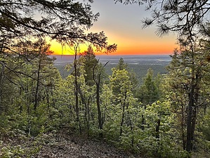
Volcanic lung stretcher by PrestonSands  Overview OverviewPorter Mountain is a prominent cinder cone volcano just north of the town of Lakeside. The hike suggested here starts at the White Mountains Trail System’s Flume Connector trailhead, but one can also just hike forest road 223 the entire distance. Either way, one will need to follow the Porter Mountain gravel road to the summit. Some may not care for a road hike, but this hike offers a good workout if in the area, and a pleasant hill climb to a lofty viewpoint in an otherwise relatively flat area.
From the Flume Connector trailhead, follow the signed trail north out of the parking lot. The trail soon curves left (west) to cross forest road 206, so watch for the white diamond-shaped White Mountains Trail System markers nailed to trees to stay on route. At about 0.1 miles, make a hard left to follow the Flume Connector Trail uphill to the southwest. Follow the trail another 0.3 miles to where it crosses the wide gravely route of forest road 223. Turn right and head uphill on road 223. You’ll soon pass an old cinder quarry and make a switchback curve to the south to continue your ascent on the road. At 1.1 miles from the trailhead, you’ll reach another switchback and informal parking area/viewpoint, just below a gate that blocks vehicles from continuing up the road. Go past the gate and continue up the road along the mountain’s crest and past the communication towers at the summit. At the end of the road at the summit’s west end is a nice lofty view of the Pinetop/Show Low area, a great place to watch the sunset. Return the same way. Gate Policy: If a gate is closed upon arrival, leave it closed after you go through. If it is open, leave it open. Leaving a closed gate open may put cattle in danger. Closing an open gate may cut them off from water. Please be respectful, leave gates as found. The exception is signage on the gate directing you otherwise. Check out the Triplog. Leave No Trace and +Add a Triplog after your hike to support this local community. | |||||||||||||||||||||||||||||||||||||||||||||||||||||||||||||||||||||||||||||