username
X
password
register
for free!
help
  This is likely a great time to hike this trail!  Check out "Preferred" months below, keep in mind this is an estimate.
  

Lake Estelle Trail #36 - ID Panhandle NF, ID

Guide 1 Triplog  0 Topics
  4 of 5  
Fav
Wish
0
details
drive
permit
forecast
route  
stats
photos
triplog
topics
location
14 1 0
Statistics
tap row or icons for details
Difficulty 1.5 of 5
Route Finding 1 of 5
Distance One Way 2.06 miles
Trailhead Elevation 5,161 feet
Elevation Gain 605 feet
Accumulated Gain 674 feet
Avg Time One Way 1-1.5 hrs
Kokopelli Seeds 4.31
 Backpack Yes
feature photo
Photos Viewed All MineFollowing
14  2023-07-01 LindaAnn
Author
author avatar Guides 110
Routes 2,246
Photos 8,982
Trips 2,600 map ( 15,998 miles )
Age 45 Female Gender
Location Ahwatukee, AZ
Historical Weather
Trailhead Forecast
Radar Map
Expand Map
Preferred Jul, Aug, Sep, Oct → 9 AM
Seasons   Summer to Autumn
Sun  6:06am - 7:20pm
Official Route & 1 Rt
 
0 Alternative


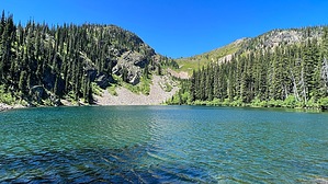
chiseled by giant sheets of ice
by LindaAnn

  Likely In-Season!
Overview: An easy-moderate hike up to Lake Estelle in the western Cabinet Mountains. There are a few places to camp along the shore of the lake, making backpacking an option.


Getting There: From the Moose Lake Trailhead, take Moose Lake Trail east for approx 0.90 miles to the signed junction with Lake Estelle Trail.
remove free decal offer
Hike: From the signed junction, turn left and head north on Lake Estelle Trail. The trail gradually climbs uphill as you wind your way through the dense forest. Views are limited for the first mile. After a little more than a mile, a large rock outcropping appears above and to the left of the trail. As the trail curves around these rocks, views open up to the east and north. The slabs of rock are impressive as you hike along the base of them. Once you turn west around the rocks, you will be nearing the lake, which is not visible until you are right on the east shore. Large granite boulders strewn about remind you that this area was carved by glaciers in the past.

The lake is fairly small, just a few acres, but fills the cirque. A handful of campsites dot the shore, and a small use trail heads south towards a rocky slope, which has some nice places to sit and enjoy the views. While some lakes in the area have food lockers, there did not appear to be any at Lake Estelle, so plan accordingly if camping, as bears frequent the area.

Once done, retrace your steps back downhill. The hike back is easy, although there are some rocks and tree roots to contend with in places.

2023-07-01 LindaAnn


    Check out the Official Route and Triplog.
    Leave No Trace and +Add a Triplog after your hike to support this local community.

    One-Way Notice
    This hike is listed as One-Way.

    When hiking several trails on a single "hike", log it with a generic name that describes the hike. Then link the trails traveled, check out the example.
    WARNING! Hiking and outdoor related sports can be dangerous. Be responsible and prepare for the trip. Study the area you are entering and plan accordingly. Dress for the current and unexpected weather changes. Take plenty of water. Never go alone. Make an itinerary with your plan(s), route(s), destination(s) and expected return time. Give your itinerary to trusted family and/or friends.

     Permit $$
    FS
    Backpacking camping permits: request 2 weeks in advance


     Directions
    or
     Road
    High Clearance possible when dry

    To hike
    To hike
    From Coeur d'Alene, take US-95 north to Sandpoint. At Sandpoint, take Hwy 200 East to Trestle Creek Rd. Turn left on Trestle Creek Rd, which turns into FS-275. Take FS-275 up to where it ends at FS-419. Turn left at FS-419 and take it another 3 miles to where it ends at Moose Lake trailhead.

    FS-275 is car-friendly. FS-419, especially the last 2 miles of it, is medium clearance. There are places to park alongside the road if you wanted to walk the last 2 miles to the trailhead.

    Searching "Moose Lake" in google maps also provides the same directions.
    page created by LindaAnn on Jul 01 2023 5:39 pm
     90+° 8am - 6pm kills
    helpcorrectionissue

    end of page marker