username
X
password
register
for free!
help
 This is likely a great time to hike this trail!  Check out "Preferred" months below, keep in mind this is an estimate.
  

Snow Lake Trail #185 - ID Panhandle NF, ID

Guide 1 Triplog  0 Topics
  4 of 5  
Fav
Wish
0
details
drive
permit
forecast
route  
stats
photos
triplog
topics
location
14 1 0
Statistics
tap row or icons for details
Difficulty 1.5 of 5
Route Finding 1 of 5
Distance One Way 4.35 miles
Trailhead Elevation 4,347 feet
Elevation Gain 1,579 feet
Accumulated Gain 1,601 feet
Avg Time One Way 2.5 hrs
Kokopelli Seeds 9.69
 Interest Seasonal Creek & Perennial Creek
 Backpack Yes
feature photo
Photos Viewed All MineFollowing
14  2023-07-03
Bottleneck Lake & Snow Lake
LindaAnn
Author
author avatar Guides 110
Routes 2,246
Photos 8,982
Trips 2,600 map ( 15,998 miles )
Age 45 Female Gender
Location Ahwatukee, AZ
Historical Weather
Trailhead Forecast
Radar Map
Expand Map
Preferred Jul, Aug, Sep, Oct
Seasons   Summer to Late Autumn
Sun  6:09am - 7:20pm
Official Route
 
1 Alternative


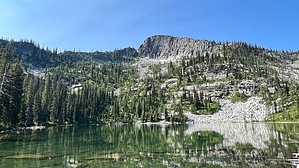
ridgeline dreams and granite wishes
by LindaAnn

 Likely In-Season!
Overview: Easy hike to Snow Lake in the Selkirk Mountains. Camping or fishing at the lake is an option or can be combined with Bottleneck Lake Trail# 187 for a fairly easy 12.50-mile hike.


Hike: The trail starts next to a large, brown Forest Service sign and is easy to spot. The first 1.50 miles is a shared trail with Bottleneck Lake Trail #187 on an old road. The incline is mild, and hiking the old road is easy. There are several water crossings, which are generally easy but may be more challenging during spring runoff. The largest crossing is Corner Creek.
remove free decal offer
Not long after Corner Creek, at 1.50 miles, there is a signed junction. Stay left to continue on Snow Lake Trail. The trail continues uphill, mostly on an old road bed. Views through the trees are somewhat limited, but there are glimpses of the surrounding ridgelines, including Bottleneck Peak to the west. Snow Creek can be heard along the trail but stays mostly hidden. You will cross Bottle Creek and Snow Creek as you gently climb uphill.

There is an obvious fork at about the 3-mile mark, take the left fork to stay on the main trail. There are some rocky sections of trail, but those are short-lived and it is mostly good footing. Eventually, Snow Lake comes into view ahead of you. Following the trail along the north side of the lake, and across a few boardwalks, leads to a nice campsite, and probably the best views of the lake. The surrounding granite walls of the cirque are impressive. A tall peak looms over the south end of the lake, but the near vertical walls around the lake look challenging at best.

After enjoying the views, retrace your steps back downhill, which goes by quickly with the good trail conditions.

2023-07-03 LindaAnn


    Check out the Official Route and Triplog.
    Leave No Trace and +Add a Triplog after your hike to support this local community.

    One-Way Notice
    This hike is listed as One-Way.

    When hiking several trails on a single "hike", log it with a generic name that describes the hike. Then link the trails traveled, check out the example.
    WARNING! Hiking and outdoor related sports can be dangerous. Be responsible and prepare for the trip. Study the area you are entering and plan accordingly. Dress for the current and unexpected weather changes. Take plenty of water. Never go alone. Make an itinerary with your plan(s), route(s), destination(s) and expected return time. Give your itinerary to trusted family and/or friends.

     Permit $$
    FS
    Backpacking camping permits: request 2 weeks in advance


     Directions
    or
     Road
    FR / Dirt Road / Gravel - Car Okay

    To hike
    The road is suitable for all vehicles when dry.

    From Sandpoint, head north on US-2/95 approx 23 miles to Old Hwy 95/Deep Creek Loop at the town of Naples. Turn left on Old Hwy 95/Deep Creek Rd and follow it north for 6.30 miles to Lions Den Rd and turn left. Take Lions Den Rd west, then north (don't miss the turn just before the railroad tracks) for 2.10 miles to Snow Creek Rd/FR402, which is not well signed, but is just past crossing the bridge over Snow Creek. Turn left on Snow Creek Rd (left fork) and follow it approx 9.50 miles to the end of FR402 and the trailhead parking on the right side of the road.
    page created by LindaAnn on Jul 03 2023 5:35 pm
     90+° 8am - 6pm kills
    helpcorrectionissue

    end of page marker