username
X
password
register
for free!
help
  This is likely a great time to hike this trail!  Check out "Preferred" months below, keep in mind this is an estimate.
 

Bear Valley Marsh Creek Trail #4010, ID

Guide 1 Triplog  0 Topics
  4 of 5  
Fav
Wish
1
details
drive
no permit
forecast
route  
stats
photos
triplog
topics
location
10 1 0
Statistics
tap row or icons for details
Difficulty 2.5 of 5
Route Finding 3 of 5
Distance One Way 4.6 miles
Trailhead Elevation 6,365 feet
Elevation Gain -204 feet
Accumulated Gain 372 feet
Kokopelli Seeds 5.84
 Interest Perennial Creek
feature photo
Photos Viewed All MineFollowing
10  2023-07-01 FOTG
Author
author avatar Guides 37
Routes 556
Photos 10,872
Trips 1,052 map ( 10,600 miles )
Age 43 Male Gender
Location AZ
Co-Author
co-author avatarGuides 16,843
Routes 17,472
Photos 24
Trips 1 map (6 Miles)
Age 28 Male Gender
Location HAZ, TrailDEX
Historical Weather
Trailhead Forecast
Radar Map
Expand Map
Preferred Jul, Aug, Aug, Sep → 7 AM
Sun  6:07am - 7:12pm
Official Route & 1 Rt
 
0 Alternative


Returnlessly Waterlogged
by FOTG & HAZ_Hikebot

  Likely In-Season!
Overview
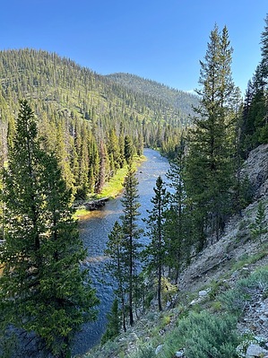
John Stanley named the area bear valley due to the substantial amount of bears they observed feeding on salmon in the river when they went through the area in the 1860s.


Wiki history of the nearby town of Stanely.
remove free decal offer
Hike
A pack bridge from the trailhead will take you across Bear Valley Creek, where you will immediately see a wilderness sign, turn right, and continue downstream to the trail's terminus at the Middle Fork. Bear Valley Creek can be a difficult early season ford and the trail crosses the river three times on the way to the trail's main attraction, a stunning set of hot springs about 4.5 miles downstream from the trailhead.


2023-07-14 FOTG & HAZ_Hikebot


    Check out the Official Route and Triplog.
    Leave No Trace and +Add a Triplog after your hike to support this local community.

    One-Way Notice
    This hike is listed as One-Way.

    When hiking several trails on a single "hike", log it with a generic name that describes the hike. Then link the trails traveled, check out the example.
    WARNING! Hiking and outdoor related sports can be dangerous. Be responsible and prepare for the trip. Study the area you are entering and plan accordingly. Dress for the current and unexpected weather changes. Take plenty of water. Never go alone. Make an itinerary with your plan(s), route(s), destination(s) and expected return time. Give your itinerary to trusted family and/or friends.

     Permit $$
    None


     Directions
    or
     Road
    Paved - Car Okay

    To hike
    From ID-21 (about 8.2mi)
    Head northwest on Bear Valley Rd -> 7.9 mi
    Turn right onto Forest Rd 579A -> 0.2 mi
    Continue straight onto Forest Rd 579A1
    page created by FOTG on Jul 13 2023 8:10 pm
     90+° 8am - 6pm kills
    helpcorrectionissue

    end of page marker