Route Editor

| Guide | ♦ | 1 Triplog | 0 Topics |
details | drive | no permit | forecast | route |
stats |
photos | triplog | topics | location |
| 10 | 1 | 0 |
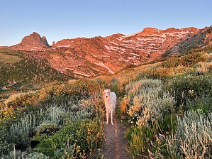
When in Wells by FOTG Smith Lake is an excellent destination if you are in the area and looking to stretch your legs a little, or if you happen to find yourselves camped at one of the two campgrounds in the area, in particular, the Angel Lake Campground. There is a parking area for Smith Lake, however, there are no signs or informational kiosks indicating the beginning of the trail or trail name. The lake offers a pretty superb little destination for the small effort required in getting there. Hike The hike begins from the large lot just before entering the Angel Lake Campground and day-use area. Angel Lake is a reservoir, however, a nice waterfall cascades down into the backside of the lake, so it's worth a stop on your way out. As mentioned, there is no trail sign or informational kiosk at the trailhead. Follow the obvious tread north out of the parking lot.
The trail continues to climb at a modest grade through a nice stretch of grasses and flowers and then a stretch of sagebrush until it starts to steepen with the final push to the lake. After topping out along the outlet stream, the quaint, but scenic lake will appear. Two distinct trails seem to provide access to the lake, the trail to the right immediately crosses the outlet stream and then enters a bouldery area that is not overly pleasant, take the trail to the left, which brings you right to the lake shore. Although, it should be noted the shoreline in general is not overly conducive to lake access and is a bit brushy and crowded with aspens and boulders. An apparent campsite near the lake probably provides the best spot to take a break. When finished at the lake, return the way you came. Note Despite its elevation, the first portion of the trail has the potential to get really hot in the summer. It's exposed to the sun and there is no shade, or water until the lake. An early start is suggested for general comfort, or if hiking with dogs. Gate Policy: If a gate is closed upon arrival, leave it closed after you go through. If it is open, leave it open. Leaving a closed gate open may put cattle in danger. Closing an open gate may cut them off from water. Please be respectful, leave gates as found. The exception is signage on the gate directing you otherwise. Check out the Official Route and Triplog. Leave No Trace and +Add a Triplog after your hike to support this local community. | |||||||||||||||||||||||||||||||||||||||||||||||||||||||||||||||||||||||||||||||||||||