Route Editor

| Guide | ♦ | 3 Triplogs | 0 Topics |
details | drive | no permit | forecast | route |
stats |
photos | triplogs | topics | location |
| 24 | 3 | 0 |
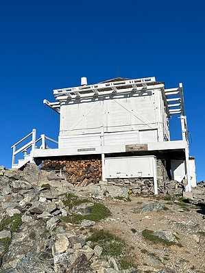
The adventure is getting there. by FOTG The Salmon Mountain lookout is the oldest documented lookout in the Bitterroot Mountains. It was originally manned from a tent in the 1920s and then it went to a cabin before the current lookout you see today, which was built in 1949. The Salmon Mountain lookout remains staffed by volunteers during the fire season and is on the National Register of Historic Places. Salmon Mountain is the highest peak in the Frank Church River of No Return Wilderness. Getting There The trailhead for the Salmon Mountain Lookout Trail is remote. In fact, the national forest states it is one of the most remote regions of the contiguous 48. There are no services available anywhere near the trailhead and for many the process of getting to the trailhead will be the true adventure when completing this hike. The trailhead is approximately 47 miles in from the western terminus of the Magruder Corridor or about 63 miles in if coming from the City of Darby Montana. The approach from the Montana side is said to be the better drive, in terms of road conditions. Plan accordingly.
The Salmon Mountain Lookout Trail begins from a pullout on the driver's left, which is large enough for a couple of vehicles, or so. The trail begins on an old road bed and starts with a steady climb through a nice forested section of the usual conifers mixed in with some whitebark pine snags and perhaps the highlight of the trail, some subalpine larch. According to one source, this could perhaps represent one of the species' most southern occurrences. After about a half mile, the forest will open up some as the trail reaches a flatter section where the lookout will come into view for the first time. After about three-quarters of a mile, you will begin to approach the cirque and impressive cliffs the lookout sits on. A lake below comes into view as well. Mountain goats are a common sighting among the talus and rocky hillsides below. The trail then turns to the left for the final approach to the lookout, which is a little steeper but still generally moderate in grade. The final push to the summit is completed through a series of gentle switchbacks up the open slopes leading to the lookout. The lookout occupies a breathtaking setting on the summit of Salmon Mountain. It sits on top of a rocky outcropping right at the treeline, with unnamed alpine lakes below and cliffs guarding the northeast and southern approaches. After enjoying the superb views from this remote lookout and summit, return the way you came. Note Nobody was on duty when I was there, but a sign at the trailhead said the lookout was on duty from 0900-1800. The elevation on the lookout reads 8944 feet. Camping There are several options for camping along the Magruder Corridor. However, the primitive campground at Observation Point probably makes the most sense, if camping the night before, or after. Check out the Official Route and Triplogs. Leave No Trace and +Add a Triplog after your hike to support this local community. | |||||||||||||||||||||||||||||||||||||||||||||||||||||||||||||||||||||||||||||||||||||||||