 Route Editor

| Guide | ♦ | 1 Triplog | 0 Topics |
details | drive | permit | forecast | route |
stats |
photo | triplog | topics | location |
| 1 | 1 | 0 |
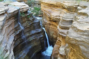
  June 2012 June 2012Climbing or rappelling in the creek narrows, with or without the use of ropes or other technical equipment, is prohibited. This restriction extends within the creek beginning at the southeast end of the rock ledges, known as the “Patio,” to the base of Deer Creek Falls. This restriction is necessary for the protection of significant cultural resources. Overview BYO Hoverboard. Check out the Official Route and Triplog. Leave No Trace and +Add a Triplog after your hike to support this local community. One-Way Notice This hike is listed as One-Way. When hiking several trails on a single "hike", log it with a generic name that describes the hike. Then link the trails traveled, check out the example. | ||||||||||||||||||||||||||||||||||||||||||||||||||||||||||||||||||


