 Route Editor

| Guide | ♦ | 4 Triplogs | 0 Topics |
details | drive | no permit | forecast | 🔥 route |
stats |
photos | triplogs | topics | location |
| 33 | 4 | 0 |
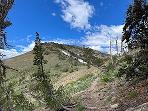
Romp with People of the Fish Net by toddak Currently about 50% complete, the Mokelumne Coast to Crest Trail (MC2CT) is envisioned as a 300+ mile trail traversing the Mokelumne River watershed between the river’s headwaters at the Sierra Crest and the river’s mouth near Martinez on the Carquinez Strait. There are three non-connected trail sections currently completed: the western section where the Mokelumne River empties into the San Francisco Bay, the Central Valley section near Camanche and Pardee Reservoirs, and the eastern section climbing from near Salt Springs Reservoir up to Ebbetts Pass along the Sierra Crest (this guide).
There are no signs indicating the MC2CT at the start, cross the bridge and hike up the paved road through the day-use area, posts with the MC2CT badge can be found where the dirt forest road begins. After about 1.6 miles on the road, a well-signed singletrack trail begins. The route climbs steadily from about 3200' elevation passing Calaveras Dome and Salt Springs Reservoir to the ski resort town of Bear Valley and the crossing of state Highway 4 at about the 20-mile mark and 7000' elevation. The route then continues to climb roughly parallel to Highway 4 for around 10 miles passing Lake Alpine to Mosquito Lakes at 8000'. The route then leaves the highway traveling south and east into the Carson-Iceberg Wilderness, passing the Highland Lakes (headwaters of the Mokelumne River) then joining the Pacific Crest Trail for the final 8 miles to the terminus slightly north of Ebbetts Pass. Check out the Official Route and Triplogs. Note This is a more difficult hike. It would be unwise to attempt this without prior experience hiking. Leave No Trace and +Add a Triplog after your hike to support this local community. One-Way Notice This hike is listed as One-Way. When hiking several trails on a single "hike", log it with a generic name that describes the hike. Then link the trails traveled, check out the example. | |||||||||||||||||||||||||||||||||||||||||||||||||||||||||||||||||||||||||||||||||||||||||||||||||||||||||


