 Route Editor

| Guide | ♦ | 1 Triplog | 0 Topics |
details | drive | permit | forecast | route |
stats |
photos | triplog | topics | location |
| 23 | 1 | 0 |
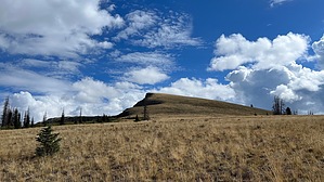
ode to Autumn by LindaAnn Hike: The trail starts on the east side of the small parking area and is an old road for the first couple hundred feet. It quickly changes to single-track as it gently climbs uphill. After a short distance, the trail crosses a bridge over a creek and then continues eastward. The trail is in good condition and seems to receive at least annual maintenance. Shade is abundant as you first hike through conifer trees, then enter a large aspen grove. Autumn would make for a very colorful hike during these first few miles of the trail.
The trail gets steeper as it winds back into the trees before popping back out at the edge of the talus field higher up. At this point, the trail turns sharply to the west, then south for the final steep climb up to a saddle on the Divide. This is the only section of the trail that has poor footing. Once you approach the saddle, the trail fades as you cross a broad field. Aiming slightly to your right to the saddle brings a sign into view, marking the trail's end at the Continental Divide. Views are good in all directions. There is a Colorado Trail Yurt visible slightly to the northeast, and it is possible to walk in either direction along the Divide for further exploration. Check out the Official Route and Triplog. Leave No Trace and +Add a Triplog after your hike to support this local community. One-Way Notice This hike is listed as One-Way. When hiking several trails on a single "hike", log it with a generic name that describes the hike. Then link the trails traveled, check out the example. | |||||||||||||||||||||||||||||||||||||||||||||||||||||||||||||||||||||||||||||||||||||||||


