Route Editor

| Guide | ♦ | 2 Triplogs | 0 Topics |
details | drive | permit | forecast | route |
stats |
photos | triplogs | topics | location |
| 27 | 2 | 0 |
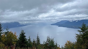
Pend Oreille's Crown by LindaAnn Hike: While there is no official starting point for this hike, parking at the hairpin turn approx 4 miles up Cherokee Rd/FS 297 does have room for a couple of vehicles to park. Beyond this point, the road is still driveable for another mile but gets narrower. To start the hike, walk south on Cherokee Rd. The grade is very moderate as you catch glimpses of Bayview and the lake ahead.
Continuing up the road, it gets slightly steeper as views to the north start to open up. The road will make a sharp turn to the left, then forks again at about 1.70 miles. Take the right fork to head east, then it will curve south. You will quickly come to another fork at about 1.85 miles. Just to the left of this fork is an open area with great views of the lake. After snapping a few pictures, take the right fork, which continues uphill and around the west side of the summit. At about 2.35 miles, you will reach a saddle of sorts and the road starts to drop downhill. Instead, make a sharp left and head up the obvious trail. It is steep and sees a lot of dirt bike traffic. From here, it is a short, but very steep, 300' climb up to the summit of Cape Horn Peak, and the only strenuous section of the hike if you are doing an out and back. Once at the summit, there are the remnants of what was probably a fire lookout. Great views in all directions as you stop to catch your breath. The distinct trail ends at the summit, but you have two options for your return: 1--retrace your steps back downhill for a fairly easy hike. 2--continue north/northeast across the summit ridge on a faint, overgrown path and reconnect to the road at the last major fork, for a more adventurous hike, but with more views. Most people with common sense will choose option 1. However, if you choose option 2, drop off the north/northeast side of the summit and head to the next high point on the ridge. There will be a faint path in places, but it's mostly just head in the correct direction. After the next little high point, the path becomes a little more visible, and you can follow it past two more "bumps" on the ridge (which also have great views) as it heads downhill. Continue following the faint path through the obstacles of fallen trees, deep erosion, and vegetation. There's nothing overly difficult, and sometimes staying just barely to the right of the visible path is the easiest option as you head downhill towards the road at the north end of the ridge. The great views ahead of you and to the right offset some of the aggravation. Before too long, you'll reach the road again and it's smooth sailing back downhill to your vehicle. Check out the Official Route and Triplogs. Leave No Trace and +Add a Triplog after your hike to support this local community. | |||||||||||||||||||||||||||||||||||||||||||||||||||||||||||||||||||||||||||||||||||||